Örménykút: Difference between revisions
Content deleted Content added
m r2.6.4) (robot Adding: sl:Örménykút |
Replaced {{unreferenced}} with {{more citations needed}} and other General fixes |
||
| (14 intermediate revisions by 13 users not shown) | |||
| Line 1: | Line 1: | ||
{{More citations needed|date=December 2023}} |
|||
{{Infobox Settlement <!--more fields are available for this Infobox--See Template:Infobox Settlement--> |
|||
{{Infobox settlement |
|||
<!-- See Template:Infobox settlement for additional fields and descriptions -->| settlement_type = <!--For Town or Village (Leave blank for the default City)--> |
|||
|subdivision_type = [[Countries of the world|Country]] |
| subdivision_type = [[Countries of the world|Country]] |
||
|subdivision_name |
| subdivision_name = {{HUN}} |
||
|latd= |latm= |lats= |latNS=N |
|||
| ⚫ | |||
|longd= |longm= |longs= |longEW=E |
|||
| ⚫ | |||
| ⚫ | |||
| ⚫ | |||
| ⚫ | |||
| ⚫ | |||
| pushpin_mapsize = |
|||
| ⚫ | |||
| ⚫ | |||
| ⚫ | |||
| |
| utc_offset = +1 |
||
| |
| timezone_DST = [[Central European Summer Time|CEST]] |
||
| ⚫ | |||
|utc_offset=+1 |
|||
| ⚫ | |||
| ⚫ | |||
| other_name = Irminčok |
|||
| ⚫ | |||
| ⚫ | |||
| |
|||
| ⚫ | |||
| ⚫ | |||
| ⚫ | |||
| ⚫ | |||
| ⚫ | |||
| ⚫ | |||
| ⚫ | |||
| ⚫ | |||
| ⚫ | |||
| ⚫ | |||
| ⚫ | |||
| ⚫ | |||
| ⚫ | |||
| ⚫ | |||
| ⚫ | |||
| ⚫ | |||
| ⚫ | |||
| ⚫ | |||
| image_shield = HUN Örménykút COA.svg |
|||
| ⚫ | |||
| shield_size = 200px |
|||
| ⚫ | |||
}} |
}} |
||
[[Image:BekesCounty. |
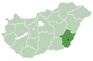
[[Image:BekesCounty.png|thumb|right|300px|Location of [[Békés County]] in [[Hungary]]]] |
||
{{Unreferenced|date=November 2007}} |
|||
'''Örménykút''' is a [[village]] in [[Békés County]], in the [[Southern Great Plain]] [[region]] of south-east [[Hungary]]. |
'''Örménykút''' ({{lang-sk|Irminčok}})<ref>{{Cite web |title=Magyarország helységnévtára |url=https://www.ksh.hu/apps/hntr.telepules?p_lang=HU&p_id=27438 |access-date=2023-12-05 |website=www.ksh.hu}}</ref> is a [[village]] in [[Békés County]], in the [[Southern Great Plain]] [[region]] of south-east [[Hungary]]. |
||
== Geography == |
== Geography == |
||
It covers an [[area]] of 54.56 km² and has a [[population]] of 549 people ( |
It covers an [[area]] of 54.56 km² and has a [[population]] of 549 people (2002). |
||
==References== |
|||
{{Reflist}} |
|||
{{Bekes}} |
{{Bekes}} |
||
{{coord|46|51|N|20|47|E|region:HU_type:city|display=title}} |
{{coord|46|51|N|20|47|E|region:HU_type:city|display=title}} |
||
{{authority control}} |
|||
{{DEFAULTSORT:Ormenykut}} |
{{DEFAULTSORT:Ormenykut}} |
||
[[Category:Slovak communities in Hungary]] |
[[Category:Slovak communities in Hungary]] |
||
[[Category: |
[[Category:Populated places in Békés County]] |
||
[[Category:Populated places in Békés county]] |
|||
{{Bekes-geo-stub}} |
{{Bekes-geo-stub}} |
||
[[eo:Örménykút]] |
|||
[[fr:Örménykút]] |
|||
[[it:Örménykút]] |
|||
[[hu:Örménykút]] |
|||
[[nl:Örménykút]] |
|||
[[pl:Örménykút]] |
|||
[[ro:Örménykút]] |
|||
[[sk:Irminčok]] |
|||
[[sl:Örménykút]] |
|||
Latest revision as of 19:28, 8 December 2023
This article needs additional citations for verification. (December 2023) |
Örménykút
Irminčok | |
|---|---|
| Country | |
| County | Békés |
| Area | |
| • Total | 54.56 km2 (21.07 sq mi) |
| Population (2002) | |
| • Total | 549 |
| • Density | 10/km2 (30/sq mi) |
| Time zone | UTC+1 (CET) |
| • Summer (DST) | UTC+2 (CEST) |
| Postal code | 5556 |
| Area code | 66 |

Örménykút (Slovak: Irminčok)[1] is a village in Békés County, in the Southern Great Plain region of south-east Hungary.
Geography[edit]
It covers an area of 54.56 km² and has a population of 549 people (2002).
References[edit]
- ^ "Magyarország helységnévtára". www.ksh.hu. Retrieved 2023-12-05.
46°51′N 20°47′E / 46.850°N 20.783°E


