Örménykút: Difference between revisions
Content deleted Content added
Replacing BekesCounty.gif with File:BekesCounty.png (by CommonsDelinker because: file renamed or replaced on Commons). |
Added Slovak name Tags: Mobile edit Mobile web edit Advanced mobile edit |
||
| Line 17: | Line 17: | ||
|utc_offset_DST=+2 |
|utc_offset_DST=+2 |
||
| |
| |
||
official_name=Örménykút| |
official_name=Örménykút|other_name=Irminčok| |
||
picture=Örménykút| |
picture=Örménykút| |
||
subdivision_type1=[[Counties of Hungary|County]]| |
subdivision_type1=[[Counties of Hungary|County]]| |
||
| Line 31: | Line 31: | ||
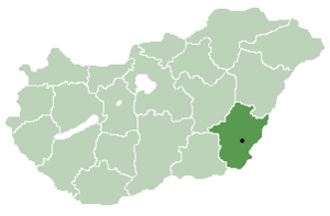
[[Image:BekesCounty.png|thumb|right|300px|Location of [[Békés County]] in [[Hungary]]]] |
[[Image:BekesCounty.png|thumb|right|300px|Location of [[Békés County]] in [[Hungary]]]] |
||
'''Örménykút''' is a [[village]] in [[Békés County]], in the [[Southern Great Plain]] [[region]] of south-east [[Hungary]]. |
'''Örménykút''' ({{lang-sk|Irminčok}}) is a [[village]] in [[Békés County]], in the [[Southern Great Plain]] [[region]] of south-east [[Hungary]]. |
||
== Geography == |
== Geography == |
||
Revision as of 19:28, 29 May 2022
Örménykút
Irminčok | |
|---|---|
| Country | |
| County | Békés |
| Area | |
| • Total | 54.56 km2 (21.07 sq mi) |
| Population (2002) | |
| • Total | 549 |
| • Density | 10/km2 (30/sq mi) |
| Time zone | UTC+1 (CET) |
| • Summer (DST) | UTC+2 (CEST) |
| Postal code | 5556 |
| Area code | 66 |

Örménykút (Slovak: Irminčok) is a village in Békés County, in the Southern Great Plain region of south-east Hungary.
Geography
It covers an area of 54.56 km² and has a population of 549 people (2002).
References
46°51′N 20°47′E / 46.850°N 20.783°E


