
Brantice
Brantice | |
|---|---|
 Centre of Brantice | |
 Flag  Coat of arms | |
 Brantice Location in the Czech Republic | |
| Coordinates: 50°3′49″N 17°37′45″E / 50.06361°N 17.62917°E | |
| Country | |
| Region | Moravian-Silesian |
| District | Bruntál |
| First mentioned | 1222 |
| Area | |
| • Total | 26.73 km2 (10.32 sq mi) |
| Elevation | 341 m (1,119 ft) |
| Population (2020-01-01[1]) | |
| • Total | 1,374 |
| • Density | 51/km2 (130/sq mi) |
| Time zone | UTC+1 (CET) |
| • Summer (DST) | UTC+2 (CEST) |
| Postal code | 793 93 |
| Website | www |
Brantice (German: Bransdorf) is a municipality and village in Bruntál District in the Moravian-Silesian Region of the Czech Republic. It has about 1,400 inhabitants.
Administrative parts
Village of Radim is administrative part of Brantice.
History
First written document mentioning Brantice is from 1222.
According to the Austrian census of 1910 the village had 1,211 inhabitants, 1,176 of whom had permanent residence there. Census asked people for their native language, 1,173 (99.8%) were German-speaking. Most populous religious group were Roman Catholics with 1,195 (98.7%).[2]
Gallery
-
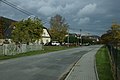 Main road
 -
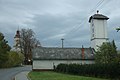
 Weir with the castle
 -
 Fire department


References
- ^ "Population of Municipalities – 1 January 2020". Czech Statistical Office. 2020-04-30.
- ^ Ludwig Patryn (ed): Die Ergebnisse der Volkszählung vom 31. Dezember 1910 in Schlesien, Troppau 1912.
External links
Wikimedia Commons has media related to Brantice.
- (in Czech) Official website
- (in Czech) Brantice Castle
- (in Czech) Website about of Brantice and nearby villages
| Authority control databases: National |
|---|
This Moravian-Silesian Region location article is a stub. You can help Wikipedia by expanding it. |