
Bruntál
| Bruntál | |||||
|---|---|---|---|---|---|
|
|||||
| Basic data | |||||
| State : |
|
||||
| Region : | Moravskoslezský kraj | ||||
| District : | Bruntál | ||||
| Area : | 3016 ha | ||||
| Geographic location : | 49 ° 59 ' N , 17 ° 28' E | ||||
| Height: | 409 m nm | ||||
| Residents : | 16,408 (Jan 1, 2019) | ||||
| Postal code : | 792 01 | ||||
| traffic | |||||
| Street: | I / 11 I / 45 |
||||
| Railway connection: |
Olomouc – Opava východ Bruntál – Malá Morávka |
||||
| structure | |||||
| Status: | city | ||||
| Districts: | 3 | ||||
| administration | |||||
| Mayor : | František Struška (as of 2010) | ||||
| Address: | Nádražní 20 792 01 Bruntál |
||||
| Municipality number: | 597180 | ||||
| Website : | www.mubruntal.cz | ||||


Bruntál ( German Freudenthal , Latin Vallis Gaudiorum ) is the district town of the Czech administrative district Bruntál ( Freudenthal ) in the Moravian-Silesian District . It has 17,631 inhabitants (2005).
geography
location
The town is located in the Sudetes east of the Jeseníky Mountains in the Lower Jeseník ( Nízký Jeseník ) in the valley of the Schwarzbach ( Černý potok ) flowing to the Mohra , surrounded by the peaks of the Köhlerberg (672 m), the basaltic cone of an extinct volcano, in the southwest, Vodárenský vrchárenský 599 m, Zadní Zelený vrch 563 m and the goat hill ( Kozinec , 639 m). Other elevations in the area are Venušina sopka (655 m), Velký Roudný (780 m) and Malý Roudný (770 m). The mountain streams Bukový potok , Kobylí potok and the Mühlbach ( Vodárenský potok ) run through the urban area.

_-_market_square.jpg)


vegetation
The original forest cover of the Jeseníky Mountains consisted of beech forests; in higher elevations there were coniferous forests. In the mountain forest there are spruce, fir, larch, birch, ash, beech, wild willow, mountain ash, sycamore. Planted curved pines grow above the upper tree line. The core of the highest quality forest resources are the most valuable parts of the Jeseníky ( Jeseníky ) and the adjacent regions of the Niedere the die ( Nízký Jeseník ). It is protected within the Jeseníký nature reserve on an area of 740 km².
City structure
Districts
|
Cadastral communities
|
history
Freudenthal was founded in 1213 and is one of the oldest Bohemian royal cities .
Until the division of 1377 Freudenthal belonged to the Duchy of Opava . After that, the city was temporarily owned by the dukes of Jägerndorf and the dukes of Ratibor and finally from 1473 by the lords of Würben auf Freudenthal. The rule was spun off from the Duchy of Jägerndorf , again added to the Duchy of Troppau and raised to a minority.
In 1474 the castle was besieged, captured and destroyed by the Hungarian King Matthias Corvinus .
After the Battle of White Mountain in 1620, the rule was confiscated by the Emperor and sold to the Teutonic Order. From 1682 to 1684, the Duchy of Freudenthal existed with the Grand Master of the Teutonic Order Johann Caspar von Ampringen as Governor of Silesia.
For centuries, mining, especially the mining of precious metals, was very important for the city and region - the miner in the city coat of arms refers to this time.
In the 19th century there was industrialization. Mainly the textile industry with leather factories, bleaching mills, spinning mills and weaving mills was of importance. The place was known for the production of the coveted Silesian house canvases . The Olomouc suburb, the Jägerndorfer suburb and the Neuss suburb also emerged during this period.
Until 1918 the city was the seat of the District Commission Freudenthal of the Crown Land of Silesia.
After the First World War , Freudenthal came to the newly created Czechoslovakia on the basis of the provisions of the Treaty of Saint-Germain signed on September 10, 1919 . By the Munich Agreement Freudenthal in 1938 together with the Sudetenland to the German Reich awarded and belonged until 1945 to the district Freudenthal in the administrative district of Opava in the Reich District of Sudetenland .
After the Second World War , Freudenthal returned to Czechoslovakia together with the Sudetenland . The predominant German population group was expelled . Your property has been confiscated ; the Catholic Church was also expropriated.
From 1960 to 2002 the city was the seat of the Okres Bruntál .
Place name
- Czech Bruntál , German Freudenthal (1325 Vreudenthal , 1397 Frewdenthal , 1405 Fraydintal , 1560–1945 Freudenthal , 1771 Freydenthal ), Polish Bruntal , Silesian Brůntal , Latin. Vallis Gaudiorum , Vrudental (1220 Freudenthal , 1238–1263 Vreudendal , 1263 Vrudental , 1290 Wreudenthal , Freudentala , Vreudenthal , Vrudenthal ).
- Czech Karlovec , German Karlsberg , Polish Karłowiec .
- Czech Kunov , German Kunau , Polish Kunów .
Originally the German name Freudenthal was used, which is already documented in old scripts as Vreudendal (1238), Vrudental (1263), Wrowdintal (1306). The Bohemian name Bruntál appears for the first time in 1456.
In some languages there are therefore two terms:
- Russian: Брунталь , Фройденталь
- Yiddish: פרויידנטל (Frojdental, Froydental)
- Greek: Μπρουντάλ ( Bruntal )
- Lithuanian: Bruntalis
- Arabic: برونتال ( Brūntāl ), Hebrew: ברונטאל ( Bruntal )
Demographics
| year | Residents | Remarks |
|---|---|---|
| 1834 | 3,608 | German residents |
| 1854 | 3,700 | |
| 1861 | 4.034 | Municipality 5.519 |
| 1880 | 7,595 | |
| 1900 | 7,759 | German residents, municipality 8,060 |
| 1910 | 8,066 | 7,725 Catholics, 229 Protestants and 97 Israelites (16 Czechs / Slovaks, ten Poles ) |
| 1921 | 8,077 | Municipality 8,597 |
| 1930 | 9,547 | thereof 396 Czechs and Slovaks, 8,904 Germans, 10 Jews, eleven Poles; City municipality 9,905 |
| 1939 | 9,569 | thereof 535 Evangelicals, 8,876 Catholics, 34 other Christians and 14 Jews |
| year | Residents | Remarks |
|---|---|---|
| 1947 | 6,348 | |
| 1961 | 8,239 | |
| 1970 | 9,686 | |
| 1980 | 14,029 | |
| 1991 | 16,800 | |
| 2001 | 17,627 | thereof 14,881 Czechs, 1,278 Moravians, 100 Silesians , 604 Slovaks , 46 Germans, 43 Poles, 22 Ukrainians |
Attractions
The historic city center including the Freudenthal Castle ( Zámek Bruntál ) was declared a monument zone. Well-known monuments include the parish church of the Assumption of Mary, the Gabriel House, the Piarist Church of Maria Trösterin with monastery, the society house, the chapel of St. Michael, the Mildner Villa and the Evangelical Church.
An almost 200- year-old four-row avenue of lime trees leads to the pilgrimage church “Maria Hilf” ( Kostel Panny Marie Pomocné ) on the Köhlerberg, which is visible from afar .
The Hussite church ( Kostel církve československo husitské ), the building of the vocational school and the commercial bank were reconstructed in the 1990s.

Pilgrimage Church of
Maria Hilf
Freudenthal Palace Museum, inner courtyard
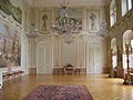
Castle Museum, residence hall of the Teutonic Order Masters

Castle museum, library


economy
tourism
Despite a number of ecological problems that are the result of ill-considered interventions in nature, the Bruntál region with its natural beauties is one of the tourist attractions of the Moravian-Silesian region .
Industry
After February 1948, there was a gradual shutdown or expropriation of local businesses - mills, sawmills, slaughterhouses, breweries, small hydroelectric plants, small businesses and the traditional textile industry.
In the 1970s and 1980s, a hydrometallurgical plant , a plastics press shop , central workshops, ČSAO , ČSAD and others were established. One of the largest state estates in the republic was created in the district.
After 1989, numerous large companies were closed and there was a shift to the service sector and small businesses.
traffic

The station is located on the Olomouc – Opava východ ( Krnov ) railway line . On weekends, trains also run on the branch line to Malá Morávka .
From Jägerndorf a road also leads today's I / 45 to Olmütz, which crosses the road I / 11 (Königgrätz-Jablunkau) in the city.
politics
mayor
- 1809–1814: Franz Josef Thiel
- 1817–1833: Cyrill Riedel (1766–1839), manufacturer
- 1833–1834: Karl Kurzweil
- 1834–1840: Josef Fenz
- 1840–1847: Florian Schneider
- 1847–1859: Franz Rudolf Wohlfarth
- 1864–1876: Anton Luft (1748-?), Manufacturer in mechanical engineering
- 1876–1887: Gustav Gabriel
- 1887–1888: Friedrich Kurzweil (1840–1912), manufacturer
- 1901–1919: Wenzel Franz Olbrich (1846–1930), manufacturer
- 1919–1922: Alois Plischke (1868-?)
- 1923–1938: Dr. Bayer
- 1938–1945: Walter Kindermann (1894–1959), master builder
Bruntál's mayor since the end of 2006 has been Ing.Fantišek Struška ( ČSSD ). The deputies are Ing. Václav Mores (SNK; Party of Free Candidates) and Bc. Petr Rys (Bruntál 2006-2010).
Town twinning
-
 Sebnitz in Saxony , Germany
-
Büdingen in Hessen , Germany
-
 Opole in the homonymous voivodeship, Poland
-
 Castellarano in Emilia-Romagna , Italy
-
 Štúrovo , Slovakia
-
 Plungė , Lithuania
The Freudenthal Altvater Heimatmuseum is located in Memmingen .
sons and daughters of the town
- Johann Riedel (1654–1736), sculptor and member of the order of the Jesuits
- Joseph Krones (1797–1832), actor
- Therese Krones (1801–1830), actress
- Franz von Neumann the Elder (1815–1888), architect
- Josef Englisch (1835–1915), Austrian urologist and surgeon
- Karl Quidenus (1839–1904), Austrian architect and master city architect
- Ernst Ludwig (1842–1915), Austrian chemist
- Ernst Berl (1877–1946), Austrian chemist
- Bruno Hanns Wittek (1895–1935), lyric poet, storyteller and poet
- Irena Anders (1920–2010), Polish stage actress and singer
- Friedrich Nather (1924–2009), civil engineer and professor
- Wolfgang Niesner (1925–1994), graphic artist
- Adolf Kutschker (1929–2009), German poet and writer
- Hertha Scholz-Peschke (* 1929), artist
- Helmut Richter (1933–2019), German writer, best known as the lyricist of the song You must go over seven bridges
- Karl Schnith (1934–1999), medieval historian
- Jörg K. Hoensch (1935–2001), German historian
- Wolfgang Peter Woseipka (* 1939), visual artist
- Sigfried Held (* 1942), soccer player and coach
- Wolfgang Michalka (* 1943), contemporary historian
- Iva Bittová (* 1958), musician and actress
- Oldřich Machala (* 1963), football player and coach
- Leo Gudas (* 1965), ice hockey player and coach
- Martin Lukeš (* 1978), football player
- Lubomír Petruš (* 1990), cyclocross and road cyclist
- Diana Mezuliáníková (* 1992), middle-distance runner
literature
- Faustin Ens : Description of the Oppaland and its inhabitants in general . Vienna 1836, pp. 190-213 .
- Jan Šícha, Eva Habel, Peter Liebald, Gudrun Heissig: Odsun. The expulsion of the Sudeten Germans. Documentation on the causes, planning and realization of an "ethnic cleansing" in the middle of Europe in 1945/46. Sudeten German Archive, Munich 1995, ISBN 3-930626-08-X .
Web links
- City of Freudenthal (Rolf Jehke, 2006)
- Official website of the city
- Website of the Heimatkreis Freudenthal / Altvater e. V.
Individual evidence
- ↑ Český statistický úřad - The population of the Czech municipalities as of January 1, 2019 (PDF; 7.4 MiB)
- ↑ Faustin Ens : Description of the Oppaland and its inhabitants in general . Vienna 1836, p. 210 .
- ↑ Karel Frantisek Eduard Kořístka: The Margraviate of Moravia and the Duchy of Silesia in their geographical environment. E. Hölzel, 1861, p. 267. Restricted preview in Google book search
- ^ Meyer's Large Conversational Lexicon . 6th edition, Volume 7, Leipzig / Vienna 1907, p. 95.
- ↑ Ludwig Patryn (Ed.): The results of the census of December 31, 1910 in Silesia , Troppau 1912, pp. 36–37, item 8.
- ^ Michael Rademacher: German administrative history from the unification of the empire in 1871 to the reunification in 1990. Freudenthal district (Czech Bruntál). (Online material for the dissertation, Osnabrück 2006).