Janov u Krnova
| Janov | ||||
|---|---|---|---|---|
|
||||
| Basic data | ||||
| State : |
|
|||
| Region : | Moravskoslezský kraj | |||
| District : | Bruntál | |||
| Area : | 1102 ha | |||
| Geographic location : | 50 ° 15 ' N , 17 ° 29' E | |||
| Height: | 410 m nm | |||
| Residents : | 293 (Jan. 1, 2019) | |||
| Postal code : | 793 84 | |||
| License plate : | T | |||
| structure | ||||
| Status: | city | |||
| Districts: | 1 | |||
| administration | ||||
| Mayor : | Milan Kaloč (as of 2018) | |||
| Address: | Janov No. 19 793 84 Janov u Krnova |
|||
| Municipality number: | 597431 | |||
| Website : | mestojanov.unas.cz/index.htm | |||
Janov (German Johannesthal ) is a town with 369 inhabitants in the Czech town of Okres Bruntál .
Geographical location
The city is located in the Sudetes in a valley in the foothills of the Bischofskoppe , six kilometers east of Zlaté Hory ( Zuckmantel ) not far from the Polish border. The Velká stříbrná ( Silberkoppe , 785 m nm) rises to the northwest
history
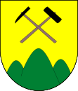
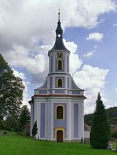
Johannesthal achieved temporary prosperity through silver mining and in 1535 gained the privileges of a mining town . In 1741 a fire caused great damage. The baroque church of the Most Holy Trinity dates back to 1783. In 1784 Johannesthal was elevated to an independent local curatie. The first pastor was the son of Obermüller Heinrich Kühn, Ferdinand Kühn, who was born in Johannesthal. A poor, hospital and orphanage was built thanks to a foundation from Julius Schmidt . There were weaving mills and knitwear production in the city .
The town in the Jägerndorf district was a Moravian enclave in Silesia . In 1930 there were 1146 inhabitants in the city, 11 of them Czech.
By the Munich Agreement Johannesthal 1938 came to the German Reich and was until 1945 the district Jägerndorf in the administrative district of Opava the Reichsgau Sudetenland .
After the end of the Second World War, Johannesthal returned to the Third Czechoslovak Republic in the summer of 1945 in accordance with the Potsdam Agreement together with the Sudetenland . The German residents were expelled in 1945 . After the Second World War Janov lost the town charter.
The former school building was set up as a community center. A teacher has put together a museum in several rooms on the upper floor. There are u. a. Both handcraft and agricultural equipment and tools from the former ore mining can be viewed. Since January 23, 2007 Janov is a city again.
Population development
| year | Residents | Remarks |
|---|---|---|
| 1834 | 1,872 | German Catholic residents |
| 1930 | 1,146 | (eleven Czechs ) |
| 1939 | 1,158 |
The town of Johannesthal had 404 inhabitants on May 22, 1947. .
Culture and sights
A memorial column on the Ringplatz commemorates the founding of the city and ore mining. In the cemetery there is a mausoleum for a couple of honorary citizens. The baroque church dedicated to the Holy Trinity dates from 1783.
literature
- Faustin Ens : The Oppaland, or the Troppauer Kreis, according to its historical, natural history, civil and local characteristics . Volume 4: Description of the locations of the principalities of Jägerndorf and Neisse, Austrian Antheils and the Moravian enclaves in the Troppauer district , Vienna 1837, p. 139.
Web links
- City of Johannesthal (Rolf Jehke, 2007)
Individual evidence
- ↑ Český statistický úřad - The population of the Czech municipalities as of January 1, 2019 (PDF; 7.4 MiB)
- ↑ Faustin Ens : The Oppaland or the Opava district, according to its historical, natural history, civic and local peculiarities . Volume 4: Description of the locations of the principalities of Jägerndorf and Neisse, Austrian Antheils and the Moravian enclaves in the Troppauer district , Vienna 1837, p. 139.
- ^ A b Michael Rademacher: German administrative history from the unification of the empire in 1871 to the reunification in 1990. Jägerndorf district. (Online material for the dissertation, Osnabrück 2006).


