Staré Heřminovy: Difference between revisions
Content deleted Content added
m →top: add authority control |
+image #WPWP |
||
| Line 2: | Line 2: | ||
{{Infobox settlement |
{{Infobox settlement |
||
<!--See the Table at Infobox Settlement for all fields and descriptions of usage--> |
<!--See the Table at Infobox Settlement for all fields and descriptions of usage--> |
||
<!-- Basic info ----------------> |
<!-- Basic info ---------------->| name = Staré Heřminovy |
||
| |
| native_name = <!-- for cities whose native name is not in English --> |
||
| |
| other_name = |
||
| ⚫ | |||
| ⚫ | |||
<!-- images and maps ----------->| image_skyline = File:Staré Heřminovy, hlavní ulice (2019-08-14; 05).jpg |
|||
| ⚫ | |||
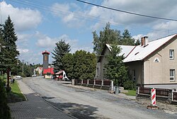
| image_caption = Street view of Staré Heřminovy |
|||
<!-- images and maps -----------> |
|||
| |
| image_flag = Staré Heřminovy vlajka.jpg |
||
| |
| image_seal = |
||
| |
| image_shield = Staré Heřminovy znak.jpg |
||
| |
| nickname = |
||
| |
| motto = |
||
| |
| image_map = |
||
| |
| map_caption = |
||
| ⚫ | |||
| ⚫ | |||
| |
| pushpin_label_position = bottom |
||
| ⚫ | |||
| ⚫ | |||
| ⚫ | |||
| pushpin_label_position = bottom |
|||
| ⚫ | |||
| ⚫ | |||
| ⚫ | |||
| ⚫ | |||
| subdivision_name = {{flag|Czech Republic}} |
|||
<!-- Location ------------------> |
|||
| ⚫ | |||
| ⚫ | |||
| ⚫ | |||
| ⚫ | |||
| |
| subdivision_type2 = [[Districts of the Czech Republic|District]] |
||
| ⚫ | |||
| ⚫ | |||
| established_title = <!-- Settled --> |
|||
| ⚫ | |||
| ⚫ | |||
| subdivision_type2 = [[Districts of the Czech Republic|District]] |
|||
| ⚫ | |||
| ⚫ | |||
| |
| government_footnotes = |
||
| |
| leader_title = |
||
| ⚫ | |||
| government_type = |
|||
| unit_pref = Imperial <!--Enter: Imperial, if Imperial (metric) is desired--> |
|||
| ⚫ | |||
| ⚫ | |||
| government_footnotes = |
|||
| ⚫ | |||
| leader_title = |
|||
| ⚫ | |||
| |
| area_metro_km2 = |
||
| ⚫ | |||
| |
| elevation_footnotes = <!--for references: use<ref> </ref> tags--> |
||
| |
| elevation_m = 473 |
||
| ⚫ | |||
| ⚫ | |||
| ⚫ | |||
| ⚫ | |||
| |
| population_as_of = 2011 |
||
| ⚫ | |||
| elevation_footnotes = <!--for references: use<ref> </ref> tags--> |
|||
| |
| population_note = <!-- General information ---------------> |
||
| timezone = [[Central European Time|CET]] |
|||
| ⚫ | |||
| ⚫ | |||
| population_footnotes = |
|||
| timezone_DST = [[Central European Summer Time|CEST]] |
|||
| ⚫ | |||
| |
| utc_offset_DST = +2 |
||
| ⚫ | |||
| ⚫ | |||
| |
| postal_code = |
||
| ⚫ | |||
<!-- General information ---------------> |
|||
| |
| website = |
||
| |
| footnotes = |
||
| |
| official_name = |
||
| ⚫ | |||
| utc_offset_DST = +2 |
|||
<!-- Area/postal codes & others --------> |
|||
| ⚫ | |||
| postal_code = |
|||
| ⚫ | |||
| ⚫ | |||
| footnotes = |
|||
| ⚫ | |||
''' Staré Heřminovy''' ({{lang-de|Alt Erbersdorf}}) is a village and municipality in [[Bruntál District]] in the [[Moravian-Silesian Region]] of the [[Czech Republic]]. <!-- The municipality covers an area of km² and as of 2006 it had a population of .---> |
''' Staré Heřminovy''' ({{lang-de|Alt Erbersdorf}}) is a village and municipality in [[Bruntál District]] in the [[Moravian-Silesian Region]] of the [[Czech Republic]]. <!-- The municipality covers an area of km² and as of 2006 it had a population of .---> |
||
Revision as of 22:19, 23 August 2020
Staré Heřminovy | |
|---|---|
Municipality and village | |
 Street view of Staré Heřminovy | |
| Coordinates: 49°56′N 17°38′E / 49.933°N 17.633°E | |
| Country | |
| Region | Moravian-Silesian Region |
| District | Bruntál District |
| Area | |
| • Total | 3.93 sq mi (10.18 km2) |
| Elevation | 1,552 ft (473 m) |
| Population (2011) | |
| • Total | 233 |
| • Density | 59/sq mi (23/km2) |
| Time zone | UTC+1 (CET) |
| • Summer (DST) | UTC+2 (CEST) |
Staré Heřminovy (German: Alt Erbersdorf) is a village and municipality in Bruntál District in the Moravian-Silesian Region of the Czech Republic.


