
Ártánd
| Ártánd | |||||
|
|||||
| Basic data | |||||
|---|---|---|---|---|---|
| State : | Hungary | ||||
| Region : | Northern Great Plain | ||||
| County : | Hajdú-Bihar | ||||
| Small area until December 31, 2012 : | Berettyóújfalu | ||||
| District since 1.1.2013 : | Berettyóújfalu | ||||
| Coordinates : | 47 ° 7 ' N , 21 ° 46' E | ||||
| Area : | 19.82 km² | ||||
| Residents : | 510 (Jan. 1, 2011) | ||||
| Population density : | 26 inhabitants per km² | ||||
| Telephone code : | (+36) 54 | ||||
| Postal code : | 4115 | ||||
| KSH kódja: | 03319 | ||||
| Structure and administration (as of 2019) | |||||
| Community type : | local community | ||||
| Mayor : | Sándor Benkő (independent) | ||||
| Postal address : | Rákóczi u. 28 4115 Ártánd |
||||
| Website : | |||||
| (Source: A Magyar Köztársaság helységnévkönyve 2011. január 1st at Központi statisztikai hivatal ) | |||||


Ártánd is a Hungarian community in the county Berettyóújfalu in Hajdú-Bihar .
geography
Ártánd borders the Romanian district of Bihor and the following municipalities:
| Bedő | Nagykereki | |
| Biharkeresztes |
.svg)
|
Borș (RO-BH) |
|
Girișu de Criș (RO-BH) |
history

Artand (center below) around 1782 (recording sheet of the Josephinische Landesaufnahme )

Ártánd (N 47 ° 8 '; E 39 ° 26') around 1892 (recording sheet of the Franzisco-Josephinische Landesaufnahme )


First mention of a settlement in 1075 under Géza I of the Árpáden family in connection with the Benedictine monastery in Hronský Beňadik .
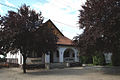
Attractions
- Country house Platthy ( Platthy-kúria )
- Millennium Monument ( Millenniumi emlékmű ), erected in 2000 by Sándor Szőke
- Reformed Church, built in 1822
- Hodossy Castle ( Hodossy-kastély )
- World War Memorial ( I-II világháborús emlékmű )
Economy and Transport
The municipality is crossed by European route 60 - which is also run as European route 79 and main road 42 - and forms the Ártánd-Bors border crossing together with the Romanian municipality of Borș . The railway connection is given by the Püspökladány – Oradea railway line .
photos
Ártánd mayor's office

Memorial plaque for Tibor Zám (1929–1984)

Ártánd-Borș border crossing


Individual evidence
- ↑ választás: többségében maradtak a hivatalban lévők Hajdú-Biharban. Hajdú Online, October 14, 2019, accessed November 5, 2019 (Hungarian).
Web links
- Ártánd in A Pallas nagy lexikona ( Hungarian )
- Ártánd község címere (Hungarian)