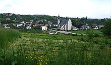
Łukowica
| Łukowica | ||
|---|---|---|

|
|
|
| Basic data | ||
| State : | Poland | |
| Voivodeship : | Lesser Poland | |
| Powiat : | Limanowski | |
| Gmina : | Łukowica | |
| Geographic location : | 49 ° 36 ' N , 20 ° 29' E | |
| Height : | 310 m npm | |
| Residents : | 2163 (March 31, 2011) | |
| Postal code : | 34-606 | |
| Telephone code : | (+48) 18 | |
| License plate : | KLI | |
| Economy and Transport | ||
| Next international airport : | Krakow-Balice | |
Łukowica is a village in the Limanowski powiat in the Lesser Poland Voivodeship . It is the seat of the rural community of the same name with about 9,900 inhabitants.
geography
Łukowica is located in the south of Lesser Poland on the border of the Beskids Island in the northwest, the Sandezer Basin in the east and the Sandezer Beskids in the southeast. The state border with Slovakia runs about 40 kilometers south of Łukowica. The Łukowica River flows through the village and flows into Dunajec . The region lies in the catchment area of the Vistula . The national road DK 28 Limanowa- Nowy Sącz runs north of the village . The distance to Limanowa is 12 kilometers, to Nowy Sącz 24 kilometers and to Kraków 76 kilometers.
history
The place was first mentioned in 1326 as Lucowicza .
Politically and administratively, the private village belonged to the Kingdom of Poland (from 1569 in the aristocratic republic of Poland-Lithuania ), Krakow Voivodeship , Sącz District. In 1444 part of the village was laid out under German law. In the time of the Reformation after 1600, the local church became the seat of an Arian congregation, i. H. of the Polish Brothers . It is said that Arian books were printed there.
After the partition of Poland in 1772, Łukowica belonged to the Austrian crown land of Galicia . During the First World War , the battle of Limanowa-Lapanow in 1914 took place in the area . After the armistice in 1918 , the Second Polish Republic was founded in November 1918 . With the attack on Poland in September 1939, the village was in the Krakow district of the General Government . At the end of January 1945 Łukowica was taken by the Red Army. After the war ended, the village belonged to the Nowy Sącz Voivodeship from 1975 to 1998 , and then to the Lesser Poland Voivodeship .
local community
The rural community (gmina wiejska) Łukowica includes ten villages with school offices.
Personalities
- Michał Sędziwój (1566–1636), Polish diplomat, philosopher, alchemist and doctor.
Individual evidence
- ^ CIS 2011: Ludność w miejscowościach statystycznych według ekonomicznych grup wieku (Polish), March 31, 2011, accessed on July 6, 2017
- ↑ Tomasz Jurek (editor): ŁUKOWICA ( pl ) In: Słownik Historyczno-Geograficzny Ziem Polskich w Średniowieczu. Edycja elektroniczna . PAN . 2010-2016. Retrieved April 22, 2019.
- ↑ Dariusz Gacek: Beskid Wyspowy. Przewodnik . Oficyna Wydawnicza "Rewasz", Pruszków 2012, ISBN 978-83-62460-25-0 , p. 250 (Polish).


