Ad-Dakhla
| العيون / ⴻⴷⴷⴰⵅⵍⴰ Dakhla |
||
|---|---|---|
|
|
||
| Coordinates | 23 ° 42 ′ N , 15 ° 57 ′ W | |
| Symbols | ||
|
||
| Basic data | ||
| Country | Western Sahara | |
| Moroccan region | Dakhla-Oued Ed Dahab | |
| ISO 3166-2 | EH | |
| Residents | 106,277 (2014) | |
|
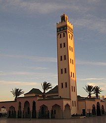
Large mosque in the center, built in the typical Moroccan style of the Koutoubia Mosque
|
||
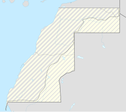
Ad-Dakhla ( Arabic الداخلة ad-Dāchla , DMG al-Dāḫila , Tamazight : ⴷⴷⴰⵅⵍⴰ), also Dakhla , Spanish spelling Dajla , former Spanish name Villa Cisneros , is the southernmost city in the Western Sahara claimedby Morocco and the capital of the administrative region Dakhla-Oued Ed Dahab . Foundedat the end of the 19th century as a Spanish trading post, the port on the only protected bay on the Atlantic coast in the Western Sahara wasa small military stationduring the Spanish colonial period until the 1930s. After the region was occupied by Morocco (1975/76), the city was placed under Moroccan administration in 1979. The economy is based on fishing and the military , a tourist development is sought.
location
Dakhla lies on a 38-kilometer-long and four-kilometer-wide headland that extends in a south-westerly direction parallel to the coast and encloses Rio de Oro , the only bay on the 875-kilometer-long coast. The Tropic of Cancer runs about 30 kilometers south. The adjacent mainland and the peninsula consist of an almost vegetation-free sand and gravel plain ( Reg ) without any agricultural land. Between the mouth of the Wadi Draa in southwest Morocco to Dakhla, the asphalt road traversing West Africa leads through an approximately 1,000 kilometer desert area. The distance from El Aaiún is just over 500 kilometers. The approximately 460 km long section of road along the coast to the south to the Mauritanian border town of Nouadhibou runs through uninhabited area with the exception of a few newly created settlements.
The west coast of the peninsula, which is open to the sea, has kilometers of sandy beaches north of the city between short rocky sections, which are only not yet developed because of the great distance to the Moroccan tourist resorts.
Population development
Official population statistics have only been kept and published since 1994.
| year | 1982 | 1994 | 2004 | 2014 |
| Residents | 17.309 | 29,831 | 58.104 | 106.277 |
The enormous increase in population is mainly due to the immigration of people from other regions of the country.
history
From 1421 Heinrich the Navigator sent ships to explore the West African Atlantic coast. In 1434, the Portuguese Gil Eanes became the first modern captain to sail around 300 kilometers to the north of Cap Bojador, which was considered impossible . On another trip two years later, he and Afonso Gonçalves Baldaia reached the coast of Dakhla. Within a few years, as the historian Gomes Eanes de Azurara wrote in 1446, around 50 caravels had circumnavigated Cap Bojador and reached the Senegal River , which was called the Rio de Oro ("Gold River"). The name Río de Oro has since been transferred to the Bay of Dakhla and, until the Spanish colonial era, also generally to the entire south of Western Sahara. The main focus for the landings and forays of the seafarers was further south of Dakhla on the island of Arguin .
After territorial disputes with the Spaniards, the Pope assigned all land south of Cap Bojador to the Portuguese in the Romanus Pontifex decree of 1456, Arguin remained their main trading base and later became the venue for battles between the Portuguese, Dutch and French; the Western Saharan coast went unnoticed.
Colonization was preceded in the 19th century by a phase in which the Spanish, British and French established trading stations on unpopulated coastal stretches to improve the exchange of goods with the inland. The Scottish trader Donald MacKenzie had received permission from the British government in 1879 to set up his North West Africa Company at Cap Juby near Tarfaya (on the Moroccan border), where he gave his post the immodest name "Port Victoria". Equally immodest and unrealistic was his unrealized plan to flood the Sahara with a canal from here to Timbuktu for shipping . After the Moroccan sultan Mulai al-Hassan I did not want to work with him economically and hindered him, he chartered a Canarian schooner and traded from the ship. Without having to moor on land for a long time, his ship was filled with gold dust, ostrich feathers and leather goods. In 1880 MacKenzie and his ship were warmly received by the locals in the Rio de Oro Bay. He started negotiations with the Emir of Adrar . In 1883 he again commuted between Cap Juby and the coast of Saguia el Hamra . Independently of this, the Sociedad de Pesqerías Canario-Africanas built a landing stage in 1881 .
When MacKenzie announced in 1884 that he wanted to open a trading post in the Rio de Oro Bay, not only the Moroccan sultan but also the Spaniards began to stand in his way. Between 1876 and 1884, five organizations with an economic interest in Africa were founded in Madrid. In January 1884 the Soc. Española de Africanistas y Colonistas (a Spanish commercial geography company) signed an agreement by Sahrawi leaders that guaranteed them commercial rights. Another company brought merchant ships into the Rio de Oro Bay until February. In November, the Spanish envoy Emilio Bonelli Hernando (1855–1926) agreed with tribal leaders to build stations on the coast. For this purpose, a trade mission traveled to the Emir of Adrar, where the heads of the most important tribes met. In the treaties the area between Adrar and the sea was assured to the Spaniards and the Spanish sovereignty over the Adrar was recognized. Finally, in December 1884, the Spanish ambassador declared the area between La Gouira in the south and Cap Bojador in the north a protectorate.
In November 1884, under Bonelli, a trading post was founded with the name Villa Cisneros , which was elected in honor of the churchman Francisco Jiménez de Cisneros . The station was built with the help Canarian workers, from where the goods should be replaced came: blue fabric, candles, sugar blocks, flintlock rifles and gunpowder. The Africans brought goats, sheep, ostrich feathers, wool, hides from wild animals, but very little gum arabic and gold dust. There were no more slaves, the slave trade had been banned since around 1800.
In March 1885 tribal members of Oulad Delim attacked the small settlement and killed several Spaniards, the rest fled to the Canary Islands. Bonelli returned with 20 soldiers three months later and set up a fortified garrison. Tribal raids on the station followed, especially in March 1887, September 1890 and March 1892, when the attack was led by a student of Mā al-ʿAinin , the most influential sheikh in the anti-colonial liberation struggle. Mā al-ʿAinin's camp was for a time about 100 kilometers east of Dakhla before he retreated to the more strategic place Smara in 1895 . After another attack in November 1894, the Spaniards achieved through a trade agreement with Mā al-ʿAinin that they would be left alone in the future.
The trading post Villa Cisneros was not a great economic success, as only a few Sahrawi caravans arrived and the world market price for ostrich feathers fell rapidly as European imports increasingly came from South Africa. In 1893 the previous Compañía Comercial Hispano-Africana was insolvent and had to be taken over by the Compañía Transatlántica . Around 1900 Villa Cisneros only survived as a small fishing port. Until 1916, when La Gouira was founded, it was the only Spanish settlement on the coast; Europeans rarely penetrated inland.
A Spanish doctor wrote in 1926 that the local population was less than 150, plus 35 soldiers, a doctor, a policeman and a pastor were stationed. In the 1930s this group was enlarged by prisoners sent by the Spanish government. Some of these political prisoners managed to escape to Dakar in a fishing boat in 1937 .
As the administrative center of the province of Río de Oro , the place grew gradually in the following decades. In 1974 5,413 Sahrawis and at least 3,000 Europeans lived in the city. In 1963 one of the world's largest underground drinking water resources was discovered, from which the city is supplied with water via a 425 meter deep borehole. When the Spaniards declared their withdrawal from their colony in the Madrid Agreement at the end of 1975, Moroccan troops reached the city on January 9, 1976 , and Mauritanian units arrived three days later. According to an agreement between the two countries on April 14, 1976, the city renamed Dhakla was added to the Mauritanian sector Tiris al-Gharbiyya. Moroccan troops were still present in the city. After the departure of the Spaniards, the Saharawi liberation movement Frente Polisario began its fight against the Moroccan and Mauritanian occupation of the country. The location on the peninsula protected the city from attacks. In August 1979 the economic and military defeat by the Polisario and civil unrest forced Mauritania to withdraw from Western Sahara.
Until the construction of the Moroccan Wall around 1985, far away in the hinterland, there was only an area of a few 100 km 2 , which was protected by a simple defensive wall and which included Ad-Dakhla and the small town of El Argoub on the opposite mainland. In 2005 there were protests against the Moroccan occupation, on May 25 a rally for an independent state was broken up by the Moroccan police.
Cityscape
Dakhla extends on the east side of the peninsula along the bay whose shores piled up in the city area and a promenade of Avenue Mohammed V was expanded. In the south, the promenade ends at warehouses in front of the port. The fishing port itself is about four kilometers south of the city on a quay that juts out far into the bay.
The right-angled business center of Ad-Dakhla extends around the vegetable market hall with the large mosque nearby. The wide main shopping street with arcades on both sides in a north-south direction is called Boulevard Walae. The quarter around the pedestrian zone one kilometer to the north near the bank promenade looks livelier. There are some simple hotels here, further north along the promenade, further accommodations, including the only luxury hotel, have been built since the turn of the millennium.
The older and new residential buildings shine in white or, like the administration buildings, have the reddish brown paint that is typical of Morocco. The Church of Nuestra Señora del Carmen , completed in 1953, has been preserved from the Spanish colonial era . At General Franco's request, it was designed in 1950 together with the church of Aaiún by the same architect who is also responsible for the Valle de los Caídos near Madrid . Church services have not been held in the white dome since 1984. In the former fort, the cannon of which pointed in the direction of the local settlement, the post office is housed in the same central square.
In 1925, the French Co. Générale Aéropostale set up airfields in Cape Juby , Villa Cisneros and Port-Étienne as bases on the post flight route Toulouse - Dakar (literarily processed by Antoine de Saint-Exupéry ). The runway in Villa Cisneros was asphalted for the first time in the 1960s; it runs within a four-kilometer-long cordoned-off area from the edge of the city center to the north. To the east of the airport on the northern outskirts is the large military barracks area; the associated entertainment district on the opposite side of the street has been built over by a steadily expanding middle-class residential area. Two arterial roads leave the city on either side of the airport to the north.
Tourism and transport
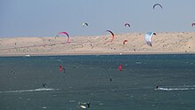
The beaches along the Dakhla peninsula are ideal for windsurfers and kite surfers , especially during the winter months. The water temperature is around 25 ° C all year round. Deep sea fishing is the second sport that Dakhla is visited for. A tourist infrastructure has been developing gradually since the turn of the millennium, there are hotels and restaurants in the city, there are no accommodations directly on the beaches.
Fishing and windsurfing competitions are held every August at Cap Sarga, the south-western tip of the peninsula . In March there is a festival to honor the sea and desert.
Several bus companies operate daily with large coaches via Aaiún north to cities in the Moroccan heartland. There is no public transport going south to Mauritania. Transport must be organized privately. The Dakhla Airport ( IATA code: VIL) several times a week served by Casablanca, as well as charter flights from the Canary islands.
climate
The climate on the Atlantic coast is hot and dry, only a wind blowing from the sea can provide a little cooling. Rain falls very rarely.
| Ad-Dakhla | ||||||||||||||||||||||||||||||||||||||||||||||||
|---|---|---|---|---|---|---|---|---|---|---|---|---|---|---|---|---|---|---|---|---|---|---|---|---|---|---|---|---|---|---|---|---|---|---|---|---|---|---|---|---|---|---|---|---|---|---|---|---|
| Climate diagram | ||||||||||||||||||||||||||||||||||||||||||||||||
| ||||||||||||||||||||||||||||||||||||||||||||||||
|
Average monthly temperatures and rainfall for Dakhla
Source: wetterkontor.de
|
|||||||||||||||||||||||||||||||||||||||||||||||||||||||||||||||||||||||||||||||||||||||||||||||||||||||||||||||||||||||||||||||||||||||||||||||||||||||||||||||||||||||||||||||||||||||||||||||||||
literature
- John Mercer: Spanish Sahara. George Allen & Unwin Ltd, London 1976
- Anthony G. Pazzanita, Tony Hodges: Historical Dictionary of Western Sahara. 2nd ed. The Scarecrow Press, Metuchen / New York / London 1994
Web links
- Dakhla. LookLex
Individual evidence
- ↑ Population development in Morocco ( Memento from March 3, 2016 in the Internet Archive )
- ^ Western Sahara (disputed territory) . citypopulation.de
- ^ Donald MacKenzie: The Flooding of the Sahara: An Account of the Proposed Plan for Opening Central Africa. Sampson Low, Marston, Searle, & Rivington, London 1877 ( at Internet Archive )
- ^ CR Pennell: Morocco Since 1830: A History. C. Hurst & Co Publishers, London 2001, p. 101
- ↑ John Mercer, 1976, pp. 104-107
- ↑ Anthony G. Pazzanita, 1994, pp. 106f
- ↑ John Mercer, 1976, p. 207


