
Agglsspitze
| Agglsspitze | ||
|---|---|---|
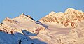
 The Agglsspitze from the Feuersteinferner (northeast) |
||
| height | 3196 m above sea level A. | |
| location | Italy, Autonomous Province of Bolzano-South Tyrol | |
| Mountains | Stubai Alps , Aggls-Rosskopf-Kamm | |
| Coordinates | 46 ° 57 '57 " N , 11 ° 14' 40" E | |
|
||
| First ascent | August 17, 1887 by Carl Hofer, Albert Wachtler from Bozen, Demeter Diamantidi from Vienna, led by Peter Kotter | |
| Normal way | Climbing tour through the southwest flank | |

The Agglsspitz (Italian Cima dell'Accla ), also called Agelsspitz , is a 3196 meter high mountain of the subgroup Aggls-Rosskopf-Kamm in the central main ridge of the Stubai Alps . It is located in the Italian autonomous province of Bolzano- South Tyrol . The top is an inconspicuous rocky summit, the first ascent of which is only vague. It has a fore summit in the form of a jagged rock, on the north side it is covered with firn . The mountain is part of a pronounced ridge that the western flint ( Montarso di Ponente , 3245 m) sends to the southeast.
First ascent
According to literature, the Agglsspitze was first climbed on August 17, 1887. The group consisted of Carl Hofer and Albert Wachtler from Bozen , as well as Demeter Diamantidi , a friend of Arthur Schnitzler , from Vienna . They were led by Peter Kotter. Originally the Wilde Freiger was supposed to be walked on from the Teplitzer Hütte , but the rising fog made you lose your bearings. However, it can no longer be determined whether the main summit of the Agglsspitze or only the pre-summit was climbed. The ascent took four and a half hours, the descent finally led via a detour to the more distant, northeastern Magdeburger Hütte .
Surroundings
The Agglsspitze is a good seven kilometers as the crow flies south of Ranalt in the Stubaital , and about 5 km north of Maiern in the Ridnauntal , a side valley west of Sterzing . It is covered in the northeast by the nutrient area of the Feuersteinferner , which extends up to a height of 3120 meters. To the southwest it falls with a wall about 350 meters high at a slope of about 30 ° from the Hohen Trough, a dead straight high valley between Pfurnsee and the Hangenden Ferner . Neighboring mountains are in the north, separated by the Magdeburger Scharte at an altitude of 3105 meters, the Westliche Feuerstein. In the south-east lies the Rochollspitze, named after its first climber, at 3,081 meters.
Bases and routes
Today's normal route to the Agglspitze leads from the southwest to the Hohe Trough , from there through the southwest flank over blockwork to the summit in, according to literature, easy climbing of difficulty UIAA I to the summit. The base for this slightest ascent is the Teplitzer Hütte (Italian: Rifugio Vedretta Pendente , at 2586 m in the uppermost Ridnaun valley), the walking time is two hours according to literature. The path of the first climbers led from the Magdeburger Scharte over the northwest ridge to the summit. A high-altitude tour also leads from the northeast over the Feuersteinferner combined with a difficult climbing passage in UIAA grade II. The base here is the Magdeburger Hütte ( Rifugio Cremona at 2,422 meters above sea level).
Literature and map
- Walter Klier : Alpenvereinsführer Stubai Alps , Munich 2006, ISBN 3-7633-1271-4
- Alpine Club Map 1: 25,000, sheet 31/1 Stubai Alps, Hochstubai
- Casa Editrice Tabacco : Carta topografica 1: 25.000, sheet 038, Vipiteno, Alpi Breonie / Sterzing, Stubai Alps
photos
The Agglsspitze (second mountain from the left) seen from Pflersch. On the right the flints
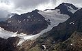
The Agglsspitze with the Feuersteinferner from the northeast
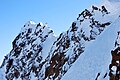
The summit seen from the northwest ridge


Individual evidence
- ↑ Ludwig Purtscheller in: Eduard Richter (Red.): The development of the Eastern Alps , Volume II, Verlag des Deutschen und Oesterreichischen Alpenverein, Berlin 1894, p. 405 f.
- ^ Walter Klier: Alpenvereinsführer Stubai Alps , Munich 2006, p. 391, margin no. 4190 ff