Ahmetli (Manisa)
| Ahmetli | ||||
|
||||

|
||||
| Basic data | ||||
|---|---|---|---|---|
| Province (il) : | Manisa | |||
| Coordinates : | 38 ° 31 ' N , 27 ° 56' E | |||
| Height : | 50 m | |||
| Residents : | 10,081 (2012) | |||
| Telephone code : | (+90) 236 | |||
| Postal code : | 45450 | |||
| License plate : | 45 | |||
| Structure and administration (as of 2013) | ||||
| Mayor : | Ahmet Alhan ( AKP ) | |||
| Website: | ||||
| Ahmetli district | ||||
| Residents : | 16,493 (2012) | |||
| Surface: | 298 km² | |||
| Population density : | 55 inhabitants per km² | |||
| Kaymakam : | Fuat Gürel | |||
| Website (Kaymakam): | ||||
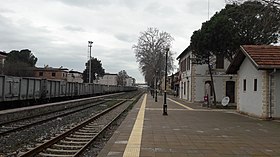
Ahmetli is a city and a district in the Turkish province of Manisa . The city is located about 50 kilometers east of the provincial capital Manisa .
The district is located in the south of the province. It borders on Turgutlu to the west, Saruhanlı and Gölmarmara to the north, Salihli to the east and İzmir Province to the south . The E-96 from Izmir to Afyonkarahisar runs through the city from west to east . In the south of the district lies the northern slope of Boz Dağları , in the north the valley of the Gediz river , the ancient Hermos .
Individual evidence
- ↑ a b Turkish Institute for Statistics ( Memento of October 4, 2013 in the Internet Archive ), accessed June 15, 2013


