Alemigssiefen
|
Alemigssiefen Alemigsiefen |
||
|
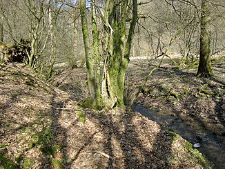
The Alemigssiefen near the mouth |
||
| Data | ||
| Water code | DE : 27288548 | |
| location |
Bergische plateaus
|
|
| River system | Rhine | |
| Drain over | Dürschbach → Sülz → Agger → Sieg → Rhine → North Sea | |
| source | at Hahn 51 ° 0 ′ 29 ″ N , 7 ° 14 ′ 13 ″ E |
|
| Source height | 238 m above sea level NHN | |
| muzzle | near Parborn in Dürschbach Coordinates: 50 ° 59 '28 " N , 7 ° 14' 46" E 50 ° 59 '28 " N , 7 ° 14' 46" E |
|
| Mouth height | 125 m above sea level NHN | |
| Height difference | 113 m | |
| Bottom slope | 47 ‰ | |
| length | 2.4 km | |
| Catchment area | 1.254 km² | |
| Discharge A Eo : 1.254 km² at the mouth |
MNQ MQ Mq |
1.68 l / s 25.31 l / s 20.2 l / (s km²) |
| Communities | Kürten | |
The Alemigssiefen or Alemigsiefen is a river between Hähn and the Parborn street in the municipality of Kürten .
Surname
While the water in the ELWAS specialist information system, in the topographic information management TIM and in the water directory , is referred to as Alemigssiefen , in landscape plans and local newspapers, Alemigsiefen is mentioned .
geography
course
The Alemigssiefen rises in the corridor In der Fuhr near the village of Hähn at an altitude of 238 m above sea level. NHN and then flows through the nature reserve Alemigsiefental . The stream runs through the Dürschbachtal nature reserve for the last few meters and spreads across the meadows located here. It then flows into the corridor An der Alemig north of the Parborn street (the Heidmannsaul residential area used to be at the neighboring fish ponds ) at a height of 125 m in the Dürschbach . The Alemigssiefen has no identifiable backwaters.
Catchment area
The 1.25 km² catchment area is located in the Bärbroicher Höhe natural area and completely in the area of the municipality of Kürten. It is drained to the North Sea via Dürschbach, Sülz , Agger , Sieg and Rhine .
The catchment area of the Alemigssiefens borders
- in the north to the Miebach
- in the northeast to the Westerbach
- in the east at its tributary Welpertssiefen
- in the southeast at the oil depths ,
- otherwise to the receiving Dürschbach.
In the floodplain of the brook, forest terrain dominates, otherwise, especially in the western area, agricultural areas predominate.
The highest point is the 243.8 m high Theisberg . Other named heights are the Wermersberg ( 204.8 m ) on the left side of the lower reaches and the Alemigsberg ( 208.2 m ) on the opposite side.
At settlements in the catchment area in the north are the Hähn residential area and the southwest area of the Hufe residential area , in the east the western part of the village of Engeldorf and to the west the area of the Unterbörsch residential area east of the main street there .
Geology and soil type
The upper reaches of the Siefens is from the clay , silt and sand as well as subordinate limestones the Eifeliumstufe the means Devon embossed and on the lower course are mainly Tons- and siltstone and partly also quartzites of Emsiums , the uppermost stage of the Devonian-series before.
Silty clay over the rocks has brown soil with high usable field capacity deposited and in the Bach depression outweighs Gleye .
Nature reserves
Web links
Individual evidence
- ^ Karlheinz Paffen , Adolf Schüttler, Heinrich Müller-Miny: Geographical land survey: The natural space units on sheet 108/109 Düsseldorf / Erkelenz. Federal Institute for Regional Studies, Bad Godesberg 1963. → Online map (PDF; 7.1 MB)
- ^ Ewald Glässer: Geographical land survey: The natural space units on sheet 122/123 Cologne / Aachen. Federal Institute for Regional Studies, Bad Godesberg 1978. → Online map (PDF; 8.7 MB)
- ↑ a b c d e ELWAS specialist information system, Ministry for Climate Protection, Environment, Agriculture, Nature and Consumer Protection NRW ( notes )
- ↑ a b Water directory of the State Office for Nature, Environment and Consumer Protection NRW 2010 (XLS; 4.67 MB) ( Notes )
- ↑ Modeled discharge values according to the specialist information system ELWAS, Ministry for Climate Protection, Environment, Agriculture, Nature and Consumer Protection NRW ( notes )
- ↑ Topographical Information Management, Cologne District Government, Department GEObasis NRW ( Notes )
- ↑ landscape plan. Retrieved March 16, 2019 .
- ↑ Nature conservation: criticism of the planned building area in Kürten. January 12, 2015, accessed on March 16, 2019 (German).
