Altenkleusheim
|
Altenkleusheim
City of Olpe
Coordinates: 51 ° 0 ′ 24 ″ N , 7 ° 55 ′ 24 ″ E
|
|
|---|---|
| Height : | 411 m |
| Residents : | 765 (Dec. 31, 2019) |
| Postal code : | 57462 |
| Area code : | 02761 |
|
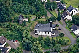
Aerial view of the Church of St. Joseph and the chapel at the Lourdes Grotto
|
|
Altenkleusheim is a district of the district town of Olpe .
geography
Altenkleusheim is located directly on the federal highway 54 between Olpe and Krombach and thus directly on the Kölschen Heck . From a cultural point of view, the neighboring border to Siegerland describes the Uerdinger and Benrath lines , which separate the West Low German- speaking place from the Moselle-Franconian language area. The village has 765 inhabitants (as of December 31, 2019).
history
Altenkleusheim was first mentioned in a document in 1383. Until 1969, Altenkleusheim, Rehringhausen and Neuenkleusheim formed the independent community of Kleusheim . This was incorporated into the district town of Olpe on July 1, 1969.
Buildings and facilities
The St. Joseph Church was built from 1959 to 1961 because the old chapel was too small. The Lourdes grotto was completed in 1913.
The place has a sports field, a tennis court, a village community hall and a shooting range.
societies
- St. Josef Schützenverein Altenkleusheim
- Sports club Altenkleusheim
- Just Voices Altenkleusheim (mixed choir)
- Kleusheim tennis club
Web links
Individual evidence
- ^ City of Olpe: residents by district , accessed on May 21, 2020.
- ↑ Martin Bünermann: The communities of the first reorganization program in North Rhine-Westphalia . Deutscher Gemeindeverlag, Cologne 1970, p. 90 .
- ↑ Village Chronicle - Chapel and later Vicarie ( Memento from March 5, 2014 in the Internet Archive )

