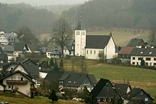
Negro (Olpe)
|
Negroes
City of Olpe
Coordinates: 51 ° 4 ′ 0 ″ N , 7 ° 53 ′ 13 ″ E
|
|
|---|---|
| Height : | approx. 410 m |
| Residents : | 360 (Dec. 31, 2019) |
| Postal code : | 57462 |
| Area code : | 02761 |
|
Aerial view of Unterneger
|
|
Neger is a district of the North Rhine-Westphalian district town of Olpe, divided into the villages of Unter- , Mittel- and Oberneger . The place name is derived from the Dorfbach Neger . The place was first mentioned in 1468.
Geographical location
Neger is located in the Ebbegebirge nature park around 5.5 km north-northeast of Olpe and around 2 km east of Lake Bigge . It is located at around 400 m above sea level. NN between the mountains Host ( 502.8 m above sea level ) in the north, Feldberg ( 556.2 m above sea level ) in the northeast, Homert ( 536.7 m above sea level ) in the east, Eichenberg ( 478.7 m above sea level) . NN ) in the south and Roschottberg ( 427.3 m above sea level ) in the west. The Neger, which is a tributary of the Bieke in the catchment area of the Bigge , flows through Ober- and Mitteleger, and it only passes through Untereger to the south.
Districts and residents
Neger consists of three villages: Untereger (275 inhabitants), Mitteleger (47 inhabitants) and Oberneger (38 inhabitants). Negro has a total of 360 inhabitants (as of December 31, 2019).
history
The distinction between the places Unterneger and Oberneger comes from the time when the office of Bilstein became part of the Mark . In 1359, Count Engelbert III bought. von der Mark took over the rule of Bilstein from Count Johann von Sayn, on which nobleman Johann von Bilstein still held the administration, but has remained childless until now. When he died in 1363, Count Engelbert III. von der Mark took the office of Bilstein as a settled man's fief, although the deceased had tried to introduce his cousin Balduin, nobleman of Steinford, to it. The Bilstein office remained in the Mark's possession until the end of the Soest feud , after which it fell back to the Archbishop of Cologne.
Count Engelbert III. Von der Mark did not get the entire office of Bilstein into his hands, as the cities of Olpe, Drolshagen and Attendorn as well as the knighthood of the office of Waldenburg and Elspe formed an alliance. In this they promised mutual help, as they wanted to stay with the Archbishopric of Cologne forever and never wanted to become part of the Mark. This alliance was renewed in 1462, 1480, and 1530. The count had to be content with the remaining part of the Bilstein office. The border was drawn through the middle of the Negro villages, so that Untereger remained with the Bilsten Office, Oberneger has since belonged to Olpe. The border ran from the “blecken Griesemert ” in front of the “new forest” along the “Elspat” to the wall, which can still be recognized today as a remnant of the Landwehr and is registered as a ground monument. "From here further down the Berendtseiffen, through the meadow, away to the ford, soon across the Holterhof meadow straight up the Zimmerberg, away this mountain straight down to the Negerische Chapel."
In 1778, on June 12th, during a general train around the Bilsteinische state border, exactly this border was established with the residents of the Gogericht Attendorn , Olpe and Rhode as well as the committees of the parishes of Kohlhagen, Rahrbach and Benolpe, which provided rifles, hoes and shovels were armed, disengaged and recorded in a record. The Schnadegang around the entire Bilstein office lasted from June 8th to 17th, 1778.
Individual evidence
- ^ City of Olpe: residents by district , accessed on May 21, 2020.
- ↑ Seibertz Documents III, No. 755
- ↑ Seibertz documents No. 981
- ↑ Heimatblätter Journal of the Heimatvereine des Kreis Olpe , 8th year, issue 1, page 4, 1931
- ^ Albert K. Hömberg : The office of Bilstein in 1555
- ^ Home voices of the Olpe district


