
Amstelbach
|
Amstelbach Anselderbeek |
||
 Headwaters in Nierstein (Richterich) |
||
| Data | ||
| Water code | DE : 28286 | |
| location |
Germany
|
|
| River system | Rhine | |
| Drain over | Wurm → Rur → Maas → Hollands Diep → North Sea | |
| River basin district | Meuse | |
| source | City of Aachen , Richterich district in Nierstein 50 ° 48 ′ 46 ″ N , 6 ° 2 ′ 39 ″ E |
|
| Source height | 183 m above sea level NN | |
| muzzle | City of Übach-Palenberg , south of Rimburg Castle in the Wurm Coordinates: 50 ° 53 ′ 41 ″ N , 6 ° 4 ′ 32 ″ E 50 ° 53 ′ 41 ″ N , 6 ° 4 ′ 32 ″ E |
|
| Mouth height | 98 m above sea level NN | |
| Height difference | 85 m | |
| Bottom slope | 6.3 ‰ | |
| length | 13.5 km | |
| Catchment area | 44.534 km² | |
The Amstelbach is a left-hand brook in the Wurm - Rur - Maas river system with its source in the North Rhine-Westphalian city region of Aachen and its mouth in the district of Heinsberg in the administrative district of Cologne .
Surname
In the Annales Rodenses , the yearbooks of the Klosterrath Abbey from the 12th century, the stream is called Anstela . In the course of time this developed from Anstel / Amstell or Anselder Beek . Even Judge Richer Bach and Mühlebach were common names. The name Amstelbach has established itself in the former Heydener Ländchen and in the rest of the brook area as well as in the NW waterway map .
geography
course
The Amstelbach has its source near the village of Nierstein in the Richterich district in the city of Aachen . The source area lies at a height of approx. 183 m above sea level . The stream with a length of 13.5 km flows in a northerly direction and is mainly used for surface drainage and for flood protection when ice and snow melt . It passes through the districts of Kircheich , Mühlenbach and Pannesheide to the east , while the district of Bank is cut through directly. At Pannesheide the Amstelbach briefly becomes the border river between Germany and the Netherlands and then crosses the Anstelvallei ( Amsteltal ), Kerkrade's green heart, as Anselderbeek. Opposite the district of Hofstadt , the stream flows into the Wurm at a height of 98 m above sea level after the Strijthagerbeek has been absorbed beforehand . The water association Eifel-Rur (WVER) is responsible for the care and maintenance of the water .
Tributaries
- Grünenthal receiving water (right), 0.4 km
- Karl-Friedrich colliery receiving water ( right ), 0.3 km
- Schönauer Bach ( right ), 1.4 km
- Geuchter Hof receiving water ( left ), 0.5 km
- Horbach ( left ), 2.5 km
- Receiver Heyder Feld ( left ), 1.0 km
- Bleyderheider Bach ( Bleijerheider Beek ) ( right ), 0.9 km
- Krombach ( Crombacher Beek ) ( left ), 2.9 km
- Vloedgraaf ( left ), 1.0 km
- Dentgenbacherbeek ( left ), 0.5 km
- Nieuw-Ehrensteinerbeek ( left ), 0.5 km
- Klooster-Anstelerbeek ( left ), 0.1 km
- Truijterbeek ( left ), 0.2 km
- Strijthager Beek ( left ), 4.5 km
- Gravenweglossing ( left ), 1.5 km
Watermills
There are or were some watermills on the Amstelbach :
- Obermühle on Scherbstrasse in Aachen-Horbach
- Untermühle on Heydener Feldweg 110 in Aachen-Horbach
- Hammolen, on the Dutch side
- Amsteler Oligsmule, on the Dutch side
- Eijelshoven Mill, on the Dutch side
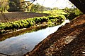
gallery

The first stretch of the Amstelbach
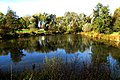
The Amstelbach flows through a pond in the Uersfeld

A generous stream bed for the Amstelbach

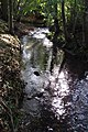
The course of the Amstelbach stream is close to nature

An attached retention basin in the bank

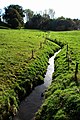
Stream course in the Bank district
Stream course at the Geuchter Hof

Building of the Obermühle am Amstelbach
Amstelbach below the Obermühle

The Amstelbach supplies the moats of the Haus Heyden castle ruins with water
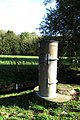
Level measuring point at Haus Heyden am Amstelbach

Stream towards Untermühle

Hubertuskapellchen directly on the Amstelbach
Stream course above the Untermühle
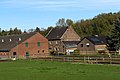
The lower mill in Aachen-Horbach
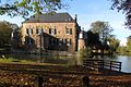
The Erenstein Castle in Kerkrade am Amstelbach


literature
- Hans Vogt: Lower Rhine water mill guide 2nd edition. Niederrhein Association, Krefeld 1998, ISBN 3-00-002906-0 , p. 277
Web links
- Euregio in the picture Amstelbach
- Euregio in the picture Haus Heyden
- Course in North Rhine-Westphalia
- Course in the province of Limburg
Individual evidence
- ↑ a b German basic map 1: 5000
- ↑ Topographical Information Management, Cologne District Government, Department GEObasis NRW ( Notes )
- ↑ Area directory for the water stationing map of the state of North Rhine-Westphalia ( Memento of the original from October 17, 2013 in the Internet Archive ) Info: The archive link was inserted automatically and has not yet been checked. Please check the original and archive link according to the instructions and then remove this notice. (PDF; 556 kB)
- ^ Eifel-Rur water association