
Obermühle (Aachen)
| Obermühle
|
||
|---|---|---|
 |
||
| Location and history | ||
|
||
| Coordinates | 50 ° 50 '28 " N , 6 ° 3' 30" E | |
| Location |
Germany
|
|
| Waters | Amstelbach | |
| Built | 1241 | |
| Shut down | 1964 | |
| technology | ||
| use | Grinding mill | |
| Grinder | 1 grind | |
| drive | Watermill | |
| water wheel | overshot | |
| Website | Website of the Obermühle | |

The Obermühle was an overshot watermill on the Amstelbach in the city of Aachen in the North Rhine-Westphalian city region of Aachen in the administrative district of Cologne .
geography
The Obermühle was located on the Amstelbach on Scherbstrasse, in the Aachen- Horbach district in the Aachen city region. It was at a height of approx. 144 m above sea level . The upper mill was the first mill on the Amstelbach, below the lower mill was located .
- cards
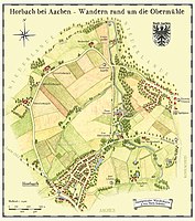
Hiking map around the Obermühle

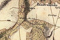
Obermühle on the tranchot card 1805/07
The upper mill on the first recording in 1846
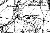
The upper mill on the new record from 1892


Waters
The Amstelbach has its source near the village of Nierstein in the Richterich district in the Aachen city region. The source area lies at a height of approx. 183 m above sea level. The stream with a length of 13.5 km flows in a northerly direction. At Pannesheide the Amstelbach briefly becomes the border river between Germany and the Netherlands and then crosses the Anstelvallei (Amsteltal), Kerkrade's green heart, as Anselderbeek. Opposite the district of Hofstadt, the stream flows into the Wurm at a height of 98 m above sea level in the town of Übach-Palenberg in the district of Heinsberg , after the Strijthagerbeek has been taken up beforehand . The water association Eifel-Rur (WVER) is responsible for the care and maintenance of the water with a catchment area of 25.7 km² .
history
The knight seat Heyden was built around 1300 by the von dem Bongart dynasty . From 1361 it was the center and administrative seat of the “Heydener Ländchen” of a Jülich subordinate . A few hundred meters away was the associated water mill, the upper mill with an overshot water wheel, which was first mentioned in 1241. As a stately facility, the mill was a ban mill for the villages of Richterich and Horbach. In front of the mill was a large mill pond in which the Amstel and Horbach rivers were diverted. From 1594 the mill was leased several times. The mill worked until 1964 and was shut down due to lack of water. Today, after renovation work, the buildings are used for further education.
- gallery

Main entrance of the Obermühle
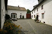
The courtyard of the Obermühle
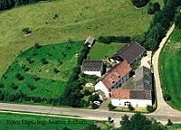
Aerial view of the entire courtyard and mill complex

The Amstelbach in the area of the Obermühle

Rear building with courtyard entrance

Millstone as a reminder of old times in the courtyard area
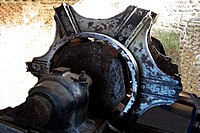
Existing wheel axle in the wheel house of the Obermühle
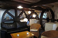
The old gear train of the Obermühle


Monument entry
Gut Obermühle, Scherbstrasse 171, until 1964 a grain mill, today a conference center, extensively restored from 1986–1994. List of monuments Aachen-Richterich
literature
- Hans Vogt: Lower Rhine water mill guide 2nd edition. Niederrhein Association, Krefeld 1998, ISBN 3-00-002906-0 , pp. 261-263
- Erich Mertes • Daniel Heidenbluth • Peter Bertram: Mills of the Eifel Volume II, Die Nordeifel, 2005, ISBN 3-938208-09-0 , pp. 163–164
→ See also the list of mills on the Wurm
Web links
Website and picture gallery of the Obermühle
Individual evidence
- ^ German basic map 1: 5000
- ↑ Topographical Information Management, Cologne District Government, Department GEObasis NRW ( Notes )
- ↑ http://www.wver.de/
At the worm : Adamsmühle | Bannmühle | Bardenberger Mill | Nivelsteiner Mill | Pumping skills of the Klosterrath pits | Pump art in the pit Ath | Pump art in the Furth pit | Pump mills | Teutermühle and Pump Art | Wolfsfurt mills
At Broicher Bach : Alsdorfer oil mill | Berger Mill | Broicher mill | Erckensmühle | Kellersberger Mill | Kranentalsmühle | Left Mill | Roman mill
Am Haarbach : Harner Mühle | Kahlgrachtmühle | Nirmer Mill | Scheidmühle | Welsche mill
At Amstel Bach : Obermühle | Under mill
On the Inde : Elgermühle, Bocksmühle, Haumühle, Hamm-Mühle, the Buschmühle,