
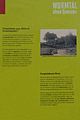
Pump mills
| Pump mills
|
||
|---|---|---|
 The former pump house of the pump mills |
||
| Location and history | ||
|
||
| Coordinates | 50 ° 49 ′ 45 " N , 6 ° 6 ′ 16" E | |
| Location | Germany | |
| Waters | worm | |
| Built | 1st H. 17th century | |
| Shut down | around 1920 | |
| technology | ||
| use | Oil, grinding, copper and grinding mills | |
| Grinder | Grinding mills and oil presses | |
| drive | Watermill | |
| water wheel | undershot | |

The pumper mills were water mills on the Wurm , which powered pumps for pit drainage in the city of Würselen in the North Rhine-Westphalian urban region of Aachen in the administrative district of Cologne . From 1648 these mills were converted and used as oil, grinding, copper and grinding mills.
geography
The pump mills were located at the Wurm at Waldstrasse / Pumper Mühle 3, in the city of Würselen. The mills were at a height of approx. 125 m above sea level . Above was the Teutermühle and the pump art , below was the Bardenberger Mühle .
Waters
The worm supplied numerous mills with water over a river length of 53 km. The source of the worm is located south of Aachen at 265 m above sea level, the confluence with the Rur is in the town of Kempen in the city of Heinsberg at 32 m above sea level. The water association Eifel-Rur (WVER) is responsible for the care and maintenance of the water body with a catchment area of 355.518 km 2 .
history
In the case of the pump mills, the development was the opposite of that of the Teutermühle and pump art. Already in the early 17th century mining with water power - swamps was operated in the pit "Der Haan" . However, after a few decades, mining was stopped again. Since mining no longer took up this location, the Aachen magistrate granted some copper masters the right to build copper mills on the former pump from his Schleiden feudal lordship . The damming heights had to be adhered to, just like in the mining industry.
Several mills were built. A later report even mentions six mills. Around 1750 thimbles were produced in three mills . At the beginning of the 19th century, oil, grinding and grinding mills for sewing needles are reported. The last pump mill was closed around 1920.
gallery
Information board about the Pumper mills near the location

Pumper mills on the new record in 1892
Pumper mills on the first recording in 1846

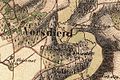
Pumper mills on the tranchot card 1805/07


literature
- Hans Vogt: Lower Rhine water mill guide 2nd edition. Niederrhein Association, Krefeld 1998, ISBN 3-00-002906-0 , p. 263
- Erich Mertes • Daniel Heidenbluth • Peter Bertram: Mills of the Eifel Volume II, Die Nordeifel, 2005, ISBN 3-938208-09-0 , p. 149
→ See also the list of mills on the Wurm
Web links
Individual evidence
- ↑ Topographical Information Management, Cologne District Government, Department GEObasis NRW ( Notes )
- ^ German basic map 1: 5000
- ↑ http://www.wver.de/
At the worm : Adamsmühle | Bannmühle | Bardenberger Mill | Nivelsteiner Mill | Pumping skills of the Klosterrath pits | Pump art in the pit Ath | Pump art in the Furth pit | Pump mills | Teutermühle and Pump Art | Wolfsfurt mills
At Broicher Bach : Alsdorfer oil mill | Berger Mill | Broicher mill | Erckensmühle | Kellersberger Mill | Kranentalsmühle | Left Mill | Roman mill
Am Haarbach : Harner Mühle | Kahlgrachtmühle | Nirmer Mill | Scheidmühle | Welsche mill
At Amstel Bach : Obermühle | Under mill
On the Inde : Elgermühle, Bocksmühle, Haumühle, Hamm-Mühle, the Buschmühle,