
Nivelsteiner Mill
| The Nivelsteiner Mühle
|
||
|---|---|---|
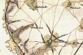
 Nivelsteiner Mühle on the tranchot card 1805/07 |
||
| Location and history | ||
|
||
| Coordinates | 50 ° 53 '35 " N , 6 ° 4' 2" E | |
| Location | Germany | |
| Waters | worm | |
| Built | before 1692 | |
| Shut down | around 1920 | |
| technology | ||
| use | Grinder and fulling mill | |
| Grinder | 1 grind | |
| drive | Watermill | |
| water wheel | undershot | |

The Nivelsteiner Mühle was a watermill on the Wurm in the city of Herzogenrath in the North Rhine-Westphalian city region of Aachen in the administrative district of Cologne .
geography
The Nivelsteiner Mühle was located on the Wurm, on Nivelsteiner Strasse, in the town of Herzogenrath. The mill building was at a height of approx. 97 m above sea level . To the south of the Nivelsteiner mill was the Bannmühle , to the north were the Rimburg mills .
Waters
The sources of the Broicher Bach with a height of 174 m above sea level are now located in a rain retention basin between the streets In der Dell and Holzweg in the Linden-Neusen district of the city of Würselen. The creek with a length of 8.2 km is a tributary of the Wurm and flows to the north in a westerly direction through the area of the city of Alsdorf and then to the city of Herzogenrath. In the road area An der Wurm / Apolloniastraße the Broicher Bach flows into the Wurm at a height of 106 m above sea level at km 35.0. A reservoir , located about 500 meters above the mouth in the Broichbachtal recreational area, regulates the flow of water from the Broich Bach into the Wurm. The water association Eifel-Rur (WVER) is responsible for the care and maintenance of the water .
history
The Nivelstein house and mill stood about 2.5 km south of Rimburg Castle . The first written mention can be found in 1692 in the Klosterrath camp register . Around 1800 the former grinding mill was registered as a fulling mill . A lease from 1846 even mentions two mills. On this side of the German territory there was a fulling mill, on the Dutch side there was a grinding and oil mill , which was not founded until 1843. It only existed until 1892 and was abandoned in 1945. The fulling mill on the German side was already partially derelict by 1920. One part of the building was still used as an inn for some time .
gallery
Nivelstein on the first recording from 1846

Nivelstein on the new recording from 1892


literature
- Hans Vogt: Lower Rhine water mill guide 2nd edition. Niederrhein Association, Krefeld 1998, ISBN 3-00-002906-0 , pp. 276-277
Web links
Individual evidence
At the worm : Adamsmühle | Bannmühle | Bardenberger Mill | Nivelsteiner Mill | Pumping skills of the Klosterrath pits | Pump art in the pit Ath | Pump art in the Furth pit | Pump mills | Teutermühle and Pump Art | Wolfsfurt mills
At Broicher Bach : Alsdorfer oil mill | Berger Mill | Broicher mill | Erckensmühle | Kellersberger Mill | Kranentalsmühle | Left Mill | Roman mill
Am Haarbach : Harner Mühle | Kahlgrachtmühle | Nirmer Mill | Scheidmühle | Welsche mill
At Amstel Bach : Obermühle | Under mill
On the Inde : Elgermühle, Bocksmühle, Haumühle, Hamm-Mühle, the Buschmühle,