
Bannmühle (Herzogenrath)
| Bannmühle in Herzogenrath
|
||
|---|---|---|
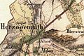
 Herzogenrath on the new recording from 1892 |
||
| Location and history | ||
|
||
| Coordinates | 50 ° 52 '5 " N , 6 ° 5' 33" E | |
| Location | Germany | |
| Waters | worm | |
| Built | 15./16. century | |
| Shut down | around 1914 | |
| technology | ||
| use | Oil and grain mill | |
| Grinder | 1 grind 1 oil press | |
| drive | Watermill | |
| water wheel | undershot | |

The Bannmühle was a watermill on the Wurm in the city of Herzogenrath in the North Rhine-Westphalian city region of Aachen in the administrative district of Cologne .
geography
The Bannmühle was located on the Wurm, on Kleikstrasse, in the city of Herzogenrath. The mill building was at a height of approx. 105 m above sea level . Above the Bannmühle was the pumping skills of the Klosterrath pits , below was the Nivelsteiner Mühle .
Waters
The sources of the Broicher Bach with a height of 174 m above sea level are now located in a rain retention basin between the streets In der Dell and Holzweg in the Linden-Neusen district of the city of Würselen. The creek with a length of 8.2 km is a tributary of the Wurm and flows to the north in a westerly direction through the area of the city of Alsdorf and then to the city of Herzogenrath. In the road area An der Wurm / Apolloniastraße the Broicher Bach flows into the Wurm at a height of 106 m above sea level at km 35.0. A reservoir , located about 500 meters above the mouth in the Broichbachtal recreational area, regulates the flow of water from the Broich Bach into the Wurm. The water association Eifel-Rur (WVER) is responsible for the care and maintenance of the water .
history
The Bannmühle belonged to Herzogenrath and most likely served as a supply unit for the castle and town in the earliest times . The first mention of the mill goes back to 1550 when the mill appeared on a city map . It is unclear whether it belonged to the sovereigns or the abbey . In the Klosterrath files of the 15./16. Century was the use of the monastery . In 1766 the abbot Haghen had the mill completely renovated. In the 18th / 19th In the 18th century it was proudly called the Imperial Bannmühle because the land of Herzogenrath was the last to belong to Austria . When valuing the properties , it was set at a net income of 750 guilders / year, making it the most highly rated property . In 1866, the Bannmühle was named as a large, well-known company of American construction . In 1910 the city of Herzogenrath acquired the property , which was demolished in 1914 in order to improve the water drainage of the Wurm, which had become difficult in the city area.
gallery
Herzogenrath on the first recording from 1846

Herzogenrath on the tranchot card 1805


literature
- Hans Vogt: Lower Rhine water mill guide 2nd edition. Association Niederrhein, Krefeld 1998, ISBN 3-00-002906-0 , pp. 275-276
Web links
Individual evidence
At the worm : Adamsmühle | Bannmühle | Bardenberger Mill | Nivelsteiner Mill | Pumping skills of the Klosterrath pits | Pump art in the pit Ath | Pump art in the Furth pit | Pump mills | Teutermühle and Pump Art | Wolfsfurt mills
At Broicher Bach : Alsdorfer oil mill | Berger Mill | Broicher mill | Erckensmühle | Kellersberger Mill | Kranentalsmühle | Left Mill | Roman mill
Am Haarbach : Harner Mühle | Kahlgrachtmühle | Nirmer Mill | Scheidmühle | Welsche mill
At Amstel Bach : Obermühle | Under mill
On the Inde : Elgermühle, Bocksmühle, Haumühle, Hamm-Mühle, the Buschmühle,