
Adam Mill
| Adam Mill
|
||
|---|---|---|
 Part of the Adam mill in Würselen |
||
| Location and history | ||
|
||
| Coordinates | 50 ° 49 '10 " N , 6 ° 6' 16" E | |
| Location | Germany | |
| Waters | worm | |
| Built | after 1456 | |
| Shut down | around 1900 | |
| technology | ||
| use | Oil u. Grinding mill | |
| Grinder | 2 grinding courses | |
| drive | Watermill | |
| water wheel | 2 undershot iron water wheels | |

The Adam Mill was a watermill on the Wurm . Today it belongs to the city of Würselen in the North Rhine-Westphalian city region of Aachen in the administrative district of Cologne .
geography
The Adamsmühle was located on the Wurm (today: Adamsmühle 1, City of Würselen). The mill building on the Wurm from the time between 1725 and 1750 is at a height of approx. 136 m above sea level . Above the Adamsmühle are the buildings of the Wolfsfurt mills , below was the Teutermühle with its pump system ("pump art") .
Waters
The worm supplied numerous mills with water over a river length of 53 km. The source of the worm is south of Aachen at 265 m above sea level, the confluence with the Rur is near the village of Kempen in the city of Heinsberg at 32 m above sea level. The water association Eifel-Rur (WVER) is responsible for the care and maintenance of the water body with a catchment area of 355.518 km 2 .
history
The first mention of the mill comes from the first archived fief register in Aachen from 1456. At that time it was named Neue Mühle . With a share transfer in 1618, Hein Adams and his family became the owners of the grinding and oil mill ; The current name of the facility comes from him. The current mill building dates from 1725 to 1750. The mill worked until around 1900 and was last operated by two undershot iron water wheels .
Two other mills are known from the area around the Adamsmühle, which are mentioned in a transfer by the Kirchmeister von Würselen in 1482: The Kalenmühle near Schweilbach was named until 1665, the Klantenmühle near Scherberg until 1558.
gallery
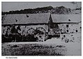
The Adam Mill in Ancient Times

The Adam mill around 1915

Mill pond of the Adam mill

Information board about the Adamsmühle

View of the worm valley near the Adamsmühle
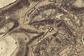
Adamsmühle on the tranchot card 1805/07

Adamsmühle on the first recording in 1846

Adamsmühle on the new recording from 1892


Monument entry
The Adamsmühle farm complex has number 6 in the list of architectural monuments in Würselen .
literature
- Hans Vogt: Lower Rhine water mill guide 2nd edition. Verein Niederrhein, Krefeld 1998, ISBN 3-00-002906-0 , pp. 260-261
→ See also the list of mills on the Wurm
Web links
Individual evidence
- ↑ Topographical Information Management, Cologne District Government, Department GEObasis NRW ( Notes )
- ^ German basic map 1: 5000
- ↑ http://www.wver.de/
At the worm : Adamsmühle | Bannmühle | Bardenberger Mill | Nivelsteiner Mill | Pumping skills of the Klosterrath pits | Pump art in the pit Ath | Pump art in the Furth pit | Pump mills | Teutermühle and Pump Art | Wolfsfurt mills
At Broicher Bach : Alsdorfer oil mill | Berger Mill | Broicher mill | Erckensmühle | Kellersberger Mill | Kranentalsmühle | Left Mill | Roman mill
Am Haarbach : Harner Mühle | Kahlgrachtmühle | Nirmer Mill | Scheidmühle | Welsche mill
At Amstel Bach : Obermühle | Under mill
On the Inde : Elgermühle, Bocksmühle, Haumühle, Hamm-Mühle, the Buschmühle,