
Harner Mill
| Harner Mill
|
||
|---|---|---|
 The Harner Mill once stood near the Haarhof |
||
| Location and history | ||
|
||
| Coordinates | 50 ° 45 '43 " N , 6 ° 9' 34" E | |
| Location |
Germany
|
|
| Waters | Haarbach | |
| Built | 1229 | |
| Shut down | 1964 | |
| technology | ||
| use | Grinding mill | |
| Grinder | 1 grind | |
| drive | Watermill | |
| water wheel | overshot | |

The Harner Mühle was an overshot watermill on the Haarbach in the city of Aachen in what is now the North Rhine-Westphalian city region of Aachen in the administrative district of Cologne .
geography
The Harner Mühle was located on Haarbach and was once part of the entire Gut Neuenhof, Haarhof and Gut Weide complex on today's Debyestrasse, which was held as a fief in the 17th and 18th centuries by the family of the mayor Johann Wilhelm von Olmüssen , known as Mülstroe, among others . was managed. It was at an altitude of about 230 m above sea level . The Harner mill was the first mill on the Haarbach, below was the Nirmer mill .
Waters
In earlier times the sources of the Haarbach were at a height of approx. 231 m above sea level near the former Driescher Hof in the city of Aachen. Today the brook begins near Gut Neuenhof and flows northeast towards Eilendorf and Haaren , where it flows into the Wurm .
history
A first mill on the Haarbach was located between Gut Neuenhof and the Haarhof on today's Debyestrasse . The first documentary mention took place between 1229 and 1331 as molendino harne . The Harnmühl near the Haarhof is on a map from 1646 . It was a grinding mill and was powered by an overshot water wheel until 1964. According to tradition, the mill building was used as a stable until the end of the 20th century.
gallery

Location of the Harner Mühle near the Haarhof on the Tranchot map 1805/07

First recording in 1846, the Harner Mühle stood at the Haarhof
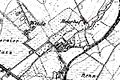
The Haarhof on the new recording from 1892


literature
- Erich Mertes, Daniel Heidenbluth, Peter Bertram: Mills of the Eifel. Volume II, Die Nordeifel, 2005, ISBN 3-938208-09-0 , p. 169
- The Haarbach, course and old mill locations
Web links
- Experience nature in the Haarbachtal (PDF file; 1.4 MB)
- Excursion to the Haarbach valley
Individual evidence
- ^ German basic map 1: 5000
At the worm : Adamsmühle | Bannmühle | Bardenberger Mill | Nivelsteiner Mill | Pumping skills of the Klosterrath pits | Pump art in the pit Ath | Pump art in the Furth pit | Pump mills | Teutermühle and Pump Art | Wolfsfurt mills
At Broicher Bach : Alsdorfer oil mill | Berger Mill | Broicher mill | Erckensmühle | Kellersberger Mill | Kranentalsmühle | Left Mill | Roman mill
Am Haarbach : Harner Mühle | Kahlgrachtmühle | Nirmer Mill | Scheidmühle | Welsche mill
At Amstel Bach : Obermühle | Under mill
On the Inde : Elgermühle, Bocksmühle, Haumühle, Hamm-Mühle, the Buschmühle,