
Left mill
| Left mill
|
||
|---|---|---|
 Left mill in Alsdorf |
||
| Location and history | ||
|
||
| Coordinates | 50 ° 51 '52 " N , 6 ° 8' 51" E | |
| Location | Germany | |
| Waters | Broicher Bach | |
| Built | before 1420 | |
| Shut down | 1970 | |
| technology | ||
| use | Grain mill | |
| Grinder | 1 grind | |
| drive | Watermill | |
| water wheel | overshot | |

The Linkens Mühle was a water mill on the Broicher Bach in the city of Alsdorf in the North Rhine-Westphalian city region of Aachen in the administrative district of Cologne .
geography
The Linkens Mühle was located on Broicher Bach on Würselener Strasse in the city of Alsdorf in the Aachen region. It lies at a height of approx. 136 m above sea level . There was a pond in front of the mill , which is now filled. Above the Linkens Mühle stood the Kellersberg mill , below the Alsdorf oil mill in the immediate vicinity .
Waters
The sources of the Broicher Bach with a height of 174 m above sea level are now located in a rain retention basin between the streets In der Dell and Holzweg in the Linden-Neusen district of the city of Würselen. The creek with a length of 8.2 km is a tributary of the Wurm and flows to the north in a westerly direction through the area of the city of Alsdorf and then to the city of Herzogenrath. In the road area An der Wurm / Apolloniastraße the Broicher Bach flows into the Wurm at a height of 106 m above sea level at km 35.0. A reservoir , located about 500 meters above the mouth in the Broichbachtal recreational area, regulates the flow of water from the Broich Bach into the Wurm. The water association Eifel-Rur (WVER) is responsible for the care and maintenance of the water .
history
The Linkens Mühle was originally owned by the Knights of Alsdorf in the 14th century . In 1420 it is mentioned as a compulsory mill for this domain. It was located on the Broicher Bach between the Jülich and Brabant border areas. There was a large pond in front of the mill . The mill with its overshot water wheel worked as a grain mill until around 1970. The Linkens Mühle, named after its owner and last miller, was also called the “Red Mill” because of its dark red paint. Traces of a mill can no longer be found on the extensive grounds today.
gallery
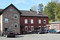
Linkens Mill house
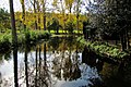
Fish ponds at Linkens Mühle
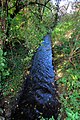
The course of the Broicher Bach

Alsdorf mills on the 1805 tranchot map

Alsdorfer Mühlen on the first recording in 1846

Alsdorfer MühlenMap of the new recording from 1892


literature
- Hans Vogt: Lower Rhine water mill guide . 2nd edition, Verein Niederrhein, Krefeld 1998, p. 273, ISBN 3-00-002906-0 .
Web links
- Nature Conservation Association Aachen
- Euregio in the picture
- Watermills on the worm ; Section: Watermills on the Broicher Bach
- The Broichbachtal , in Wolfgang Voigt: Nature in Alsdorf - a natural history walk
Individual evidence
At the worm : Adamsmühle | Bannmühle | Bardenberger Mill | Nivelsteiner Mill | Pumping skills of the Klosterrath pits | Pump art in the pit Ath | Pump art in the Furth pit | Pump mills | Teutermühle and Pump Art | Wolfsfurt mills
At Broicher Bach : Alsdorfer oil mill | Berger Mill | Broicher mill | Erckensmühle | Kellersberger Mill | Kranentalsmühle | Left Mill | Roman mill
Am Haarbach : Harner Mühle | Kahlgrachtmühle | Nirmer Mill | Scheidmühle | Welsche mill
At Amstel Bach : Obermühle | Under mill
On the Inde : Elgermühle, Bocksmühle, Haumühle, Hamm-Mühle, the Buschmühle,