
Wolfsfurt mills
| Wolfsfurt mills
|
||
|---|---|---|
 Wolfsfurt mills in Würselen |
||
| Location and history | ||
|
||
| Coordinates | 50 ° 48 '39 " N , 6 ° 6' 23" E | |
| Location | Germany | |
| Waters | worm | |
| Built | before 1200 | |
| Shut down | 1930 | |
| technology | ||
| use | Copper and grinding mill | |
| Grinder | 1 grind | |
| drive | Watermill | |
| water wheel | undershot | |

The Wolfsfurt mills were watermills on the Wurm in the city of Würselen in the North Rhine-Westphalian city region of Aachen in the administrative district of Cologne .
geography
The Wolfsfurt mills were located at the Wurm, at Wolfsfurt 2, in the city of Würselen. The mill buildings were at a height of approx. 148 m above sea level . Above the Wolfsfurt mill are the Hochbrücker mills , below are the buildings of the Adams mill .
Waters
The worm supplied numerous mills with water over a river length of 53 km. The source of the worm is located south of Aachen at 265 m above sea level, the confluence with the Rur is in the town of Kempen in the city of Heinsberg at 32 m above sea level. The water association Eifel-Rur (WVER) is responsible for the care and maintenance of the water body with a catchment area of 355.518 km 2 .
history
The first mention of the mills comes from the year 1200, when a priest Wichmann gave half of his share of the Wolvesmolen to the church . In 1622 there was a renewed transfer of ownership of now three mills on Wolfsfurt, one of which was on the western bank and another mill was derelict. The mill on the eastern side was probably the oldest and from ancient times it was initially a grain mill . Old contracts show two copper mills in 1668 and one copper and one grinding mill in 1719 .
In 1813 the Wolfsfurt mills were acquired by the cloth manufacturer Wilhelm Kuetgens, who needed a drive for the textile machines . At the imperial meeting in Aachen in 1818 , the factory was visited by Emperor Franz I of Austria . The factory worked until 1830 when it was closed. Parts of the buildings are now used as residential purposes.
A third mill, which went under as early as 1673, was probably the Clotzer Mill, which also belonged to the Wolfsfurt Mill Association.
gallery

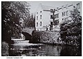
The Wolfsfurt mill after a painting around 1900
Cloth factory in Wolfsfurt in 1927
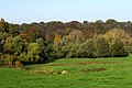
The worm valley at the Wolfsfurt mill
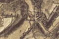
Wolffurter Mühle on the Tranchot map 1805/07

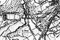
Wolfsfurter Mühle on the first recording in 1846
Wolfsfurt mill on the new recording from 1892


literature
- Hans Vogt: Lower Rhine water mill guide 2nd edition. Niederrhein Association, Krefeld 1998, ISBN 3-00-002906-0 , pp. 259-260
→ See also the list of mills on the Wurm
Web links
Mention of the Wolfsfurt mill in 1813
Individual evidence
- ↑ Topographical Information Management, Cologne District Government, Department GEObasis NRW ( Notes )
- ^ German basic map 1: 5000
- ↑ http://www.wver.de/
At the worm : Adamsmühle | Bannmühle | Bardenberger Mill | Nivelsteiner Mill | Pumping skills of the Klosterrath pits | Pump art in the pit Ath | Pump art in the Furth pit | Pump mills | Teutermühle and Pump Art | Wolfsfurt mills
At Broicher Bach : Alsdorfer oil mill | Berger Mill | Broicher mill | Erckensmühle | Kellersberger Mill | Kranentalsmühle | Left Mill | Roman mill
Am Haarbach : Harner Mühle | Kahlgrachtmühle | Nirmer Mill | Scheidmühle | Welsche mill
At Amstel Bach : Obermühle | Under mill
On the Inde : Elgermühle, Bocksmühle, Haumühle, Hamm-Mühle, the Buschmühle,