
Berger Mill
| Berger Mill
|
||
|---|---|---|
 The Berger Mühle on the original map from 1846 |
||
| Location and history | ||
|
||
| Coordinates | 50 ° 51 '53 " N , 6 ° 7' 3" E | |
| Location | Germany | |
| Waters | Broicher Bach | |
| Built | 17./18. century | |
| Shut down | 1935 | |
| technology | ||
| use | Flour mill | |
| Grinder | 3 grinding courses | |
| drive | Watermill | |
| water wheel | undershot | |

The Berger Mühle was a water mill on the Broicher Bach in the city of Herzogenrath in the North Rhine-Westphalian city region of Aachen in the administrative district of Cologne .
geography
The Berger Mühle was located on Broicher Bach, Am Erlenbruch, in the Noppenberg district in the city of Herzogenrath in the Aachen city region. It was at a height of approx. 117 m above sea level . The Roman mill was located above the Berger Mühle , below the Erckensmühle was in operation.
Waters
The sources of the Broicher Bach with a height of 174 m above sea level are now located in a rain retention basin between the streets In der Dell and Holzweg in the Linden-Neusen district of the city of Würselen. The creek with a length of 8.2 km is a tributary of the Wurm and flows to the north in a westerly direction through the area of the city of Alsdorf and then to the city of Herzogenrath. In the road area An der Wurm / Apolloniastraße the Broicher Bach flows into the Wurm at a height of 106 m above sea level at km 35.0. A reservoir , located about 500 meters above the mouth in the Broichbachtal recreational area, regulates the flow of water from the Broich Bach into the Wurm. The water association Eifel-Rur (WVER) is responsible for the care and maintenance of the water .
history
The Berger Mühle with its overshot water wheel was a grain mill in the Noppenberg district. It was in 16./17. Built in the 13th century by Baron Blankart and was probably part of Ottenfeld Castle . The Broich Bach carried so much water here that, according to a report from 1822, three of the four grinding courses could work at the same time. The mill was shut down in 1935 and converted for residential purposes. The Noppenberger Heimatverein would have liked to take over the dilapidated mill as a location and repair it, but a private individual won the race. And so came what had to come. The familiar appearance of the Mühlenhof disappeared from the scene in 1996. Today a Findlind reminds of the once so busy mill.
gallery
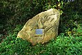
This memorial stone reminds of the Berger Mühle
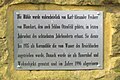
Information board about the Berger Mühle

The Broicher Bach at the Berger Mühle memorial stone

Moppenberger Mühle (Berger Mühle) re-added in 1894

Berger Mühle in the 1805 tranchot map


literature
- Hans Vogt: Lower Rhine water mill guide 2nd edition. Niederrhein Association, Krefeld 1998, ISBN 3-00-002906-0 , pp. 274-275
Web links
- Nature Conservation Association Aachen
- Euregio in the picture
- Watermills on the worm ; Section: Watermills on the Broicher Bach
- The Broichbachtal , in Wolfgang Voigt: Nature in Alsdorf - a natural history walk
- Heimatfreunde Noppenberg
Individual evidence
At the worm : Adamsmühle | Bannmühle | Bardenberger Mill | Nivelsteiner Mill | Pumping skills of the Klosterrath pits | Pump art in the pit Ath | Pump art in the Furth pit | Pump mills | Teutermühle and Pump Art | Wolfsfurt mills
At Broicher Bach : Alsdorfer oil mill | Berger Mill | Broicher mill | Erckensmühle | Kellersberger Mill | Kranentalsmühle | Left Mill | Roman mill
Am Haarbach : Harner Mühle | Kahlgrachtmühle | Nirmer Mill | Scheidmühle | Welsche mill
At Amstel Bach : Obermühle | Under mill
On the Inde : Elgermühle, Bocksmühle, Haumühle, Hamm-Mühle, the Buschmühle,