
Nirmer mill
| Nirmer mill
|
||
|---|---|---|
 Mill building of the Nirmer Mühle |
||
| Location and history | ||
|
||
| Coordinates | 50 ° 47 '13 " N , 6 ° 9' 25" E | |
| Location | Germany | |
| Waters | Haarbach | |
| Built | 1646 | |
| Shut down | after 1835 | |
| technology | ||
| use | Grinder and thimble grinder | |
| Grinder | 1 grind | |
| drive | Watermill | |
| water wheel | overshot | |

The Nirmer mill was an overshot watermill on the Haarbach in Aachen .
geography
The Nirmer Mühle was located on Haarbach , at Schuttenhofweg 232, in the Eilendorf -Nirm district in the Aachen city region. It was at a height of approx. 177 m above sea level . The Harner Mühle stood above the Nirmer Mühle , below the Scheidmühle was located .
Waters
In earlier times the sources of the Haarbach were at a height of approx. 231 m above sea level near the former Driescher Hof in the city of Aachen. Today the brook begins near Gut Neuenhof. The stream with an original length of almost 9 km is a tributary of the Wurm and flows northeast towards Eilendorf , crosses under the Aachen- Eschweiler railway line . The further path of the creek runs in a north-westerly direction, south past Verlautenheide and then into the center of Aachen- Haaren . In the city center of Haaren, the Haarbach is largely canalized. On the Tuchmacherweg, the Haarbach flows into the Wurm as an open stream at a height of about 144 m above sea level. The water association Eifel-Rur (WVER) is responsible for the care and maintenance of the water .
history
The Nirmer mill was mentioned on a map in 1646. The mill, which was also called the Vinken- und Fingerhutsmühle, was called a grinding mill in 1835 and was closed a short time later. The upstream mill pond was filled in in 1920. The remaining buildings were converted for residential purposes. During excavation work at the beginning of the 1960s, a millstone was found that today is reminiscent of earlier times.
gallery

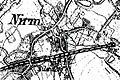
Location of Nirm on the Tranchot map 1805/07

The first photo from 1846 shows the location of Nirm
The location of Nirm on the new record from 1892


Monument entry
Nirmer Mühle , Schuttenhofweg 232, built in 1572/1640, also called thimble or Vinkenmühle (due to the production of thimble-like metal sleeves for spinning mills); later flour mill; Mill building demolished in 1832, mill pond filled in in 1920
literature
- Erich Mertes • Daniel Heidenbluth • Peter Bertram: Mühlen der Eifel Volume II, Die Nordeifel, 2005, ISBN 3-938208-09-0 , p. 169
- The Haarbach, course and old mill locations
→ See also the list of mills on the Wurm
Web links
- Experience nature in the Haarbachtal (PDF file; 1.4 MB)
- Excursion to the Haarbach valley
Individual evidence
- ^ German basic map 1: 5000
- ↑ Topographical Information Management, Cologne District Government, Department GEObasis NRW ( Notes )
- ↑ http://www.wver.de/
At the worm : Adamsmühle | Bannmühle | Bardenberger Mill | Nivelsteiner Mill | Pumping skills of the Klosterrath pits | Pump art in the pit Ath | Pump art in the Furth pit | Pump mills | Teutermühle and Pump Art | Wolfsfurt mills
At Broicher Bach : Alsdorfer oil mill | Berger Mill | Broicher mill | Erckensmühle | Kellersberger Mill | Kranentalsmühle | Left Mill | Roman mill
Am Haarbach : Harner Mühle | Kahlgrachtmühle | Nirmer Mill | Scheidmühle | Welsche mill
At Amstel Bach : Obermühle | Under mill
On the Inde : Elgermühle, Bocksmühle, Haumühle, Hamm-Mühle, the Buschmühle,