
Untermühle (Aachen)
| Under mill
|
||
|---|---|---|
 |
||
| Location and history | ||
|
||
| Coordinates | 50 ° 51 '16 " N , 6 ° 3' 22" E | |
| Location |
Germany
|
|
| Waters | Amstelbach | |
| Built | 16./17. century | |
| Shut down | 1963/64 | |
| technology | ||
| use | Grinding mill | |
| Grinder | 1 grind | |
| drive | Watermill | |
| water wheel | overshot | |

The lower mill was an overshot watermill on the Amstelbach in the city of Aachen in the North Rhine-Westphalian city region of Aachen in the administrative district of Cologne .
geography
The Untermühle was located on Amstelbach, Heydener Feldweg 110, in the Aachen- Horbach district in the Aachen city region. It was at a height of approx. 130 m above sea level . The lower mill was the second mill on the Amstelbach, above the upper mill was located .
Waters
The Amstelbach has its source near the village of Nierstein in the Richterich district in the Aachen city region. The source area is at a height of about 183 m above sea level . The stream with a length of 13.5 km flows in a northerly direction. At Pannesheide , the Amstelbach briefly becomes the border river between Germany and the Netherlands , and then as Anselderbeek it crosses the Anstelvallei (Amsteltal), Kerkrade's green heart. Opposite the district of Hofstadt, the stream flows into the Wurm at a height of 98 m above sea level in the town of Übach-Palenberg in the district of Heinsberg , after the Strijthagerbeek has been taken up beforehand . The water association Eifel-Rur (WVER) is responsible for the care and maintenance of the water body with a catchment area of 25.7 km 2 .
history
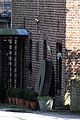
The lower mill was located near the Dutch border . The also overshot mill was a grinding mill and came from the 16./17. Because of its location on a tapering plot of land right on the border, it was also called the Tüter Mühle or Teuten Mühle . The mill, which is only reminiscent of a lone grinding stone , worked until 1963/64. The farm was converted into a horse pension.
gallery

Stream to the Untermühle
Old millstone reminds of old times

Hubertuskapellchen near the lower mill
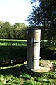
Level measuring point on the Amstelbach near the Untermühle

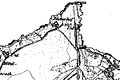
Untermühle or Tüter Mühle on the tranchot card 1805/07

The Untermühle or Teuten Mühle on the first recording in 1846
The lower mill on the new recording from 1892


Monument entry
Untermühle, Heydener Feldweg 110 (parts of) Aachen-Richterich monument list
literature
- Hans Vogt: Lower Rhine water mill guide 2nd edition. Niederrhein Association, Krefeld 1998, ISBN 3-00-002906-0 , pp. 261-263.
- Erich Mertes • Daniel Heidenbluth • Peter Bertram: Mills of the Eifel Volume II, Die Nordeifel, 2005, ISBN 3-938208-09-0 , pp. 164–165.
→ See also the list of mills on the Wurm
Web links
Individual evidence
- ^ German basic map 1: 5000
- ↑ Topographical Information Management, Cologne District Government, Department GEObasis NRW ( Notes )
- ↑ http://www.wver.de/
At the worm : Adamsmühle | Bannmühle | Bardenberger Mill | Nivelsteiner Mill | Pumping skills of the Klosterrath pits | Pump art in the pit Ath | Pump art in the Furth pit | Pump mills | Teutermühle and Pump Art | Wolfsfurt mills
At Broicher Bach : Alsdorfer oil mill | Berger Mill | Broicher mill | Erckensmühle | Kellersberger Mill | Kranentalsmühle | Left Mill | Roman mill
Am Haarbach : Harner Mühle | Kahlgrachtmühle | Nirmer Mill | Scheidmühle | Welsche mill
At Amstel Bach : Obermühle | Under mill
On the Inde : Elgermühle, Bocksmühle, Haumühle, Hamm-Mühle, the Buschmühle,