Annan (river)
| Annan | ||
|
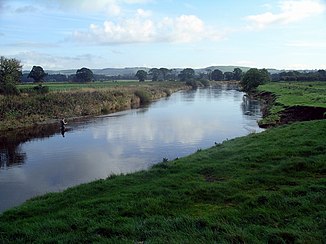
The Annan at Lochmaben |
||
| Data | ||
| location | Dumfries and Galloway , Scotland | |
| River system | Annan | |
| Drain over | Solway Firth → Irish Sea | |
| River basin district | Solway Tweed XRBD | |
| source | Confluence of several streams on the slopes of Hart Fell 55 ° 23 ′ 43 ″ N , 3 ° 28 ′ 3 ″ W |
|
| Source height | around 370 m ASL | |
| muzzle | At Annan in the Solway Firth coordinates: 54 ° 57 ′ 51 ″ N , 3 ° 15 ′ 57 ″ W 54 ° 57 ′ 51 ″ N , 3 ° 15 ′ 57 ″ W.
|
|
| length | 78 km | |
| Left tributaries | Water of Milk , Dryfe Water , Whamphray Water , Moffat Water , Birnock Water | |
| Right tributaries | Kinnel Water , Evan Water | |
The Annan ( Gaelic : Abhainn Anainn; probably from the river deity Anu) is a river in the Scottish Council Area Dumfries and Galloway . He is eponymous for the historic province of Annandale .
course
The river is created by the confluence of several source streams on the southern slopes of the Hart Fell at an altitude of around 370 m. The site is close to the boundaries of the historic counties of Lanarkshire , Peeblesshire and Dumfriesshire and a short distance from the Tweed and Clyde springs . Its approximately 78 km long run leads mainly in a southerly direction. On its upper reaches the Annan flows through a valley called Annandale, which separates the Moffat Hills from the Lowther Hills .
The Annan flows through numerous villages and a few small towns. Moffat , Johnstonebridge , Brydekirk and Annan are among the most important . Two kilometers south of Annan, the Annan flows into the Solway Firth , which eventually widens into a bay and merges into the Irish Sea .
Tributaries
Along its course, the Annan takes on numerous streams. The most important left tributaries include the Water of Milk at Ecclefechan , the Dryfe Water at Lockerbie , the Whamphray Water at Johnstonebridge, the Moffat Water and the Birnock Water at Moffat. From the right, the Kinnel Water flows into Lochmaben and the Evan Water flows into Beattock .
bridges
With the A74 (M) , the A78 , the A701 and the A709, in addition to numerous secondary roads, four trunk roads cross the Annan. Of the numerous bridges spanning the Annan, Millhouse Bridge , Shillahill Bridge , Hoddom Bridge , Brydekirk Bridge and Annan Bridge are classified as monuments of the highest Scottish monument category A.
Web links
Individual evidence
- ^ A b Annan in: FH Groome: Ordnance Gazetteer of Scotland: A Survey of Scottish Topography, Statistical, Biographical and Historical. , Grange Publishing, Edinburgh, 1885.
- ↑ a b c Entry in the Gazetteer for Scotland
- ↑ Iain Mac Tailleir: Place-names. (PDF) p. 5 , accessed on November 23, 2019 (English).
- ↑ Listed Building - Entry . In: Historic Scotland .
- ↑ Listed Building - Entry . In: Historic Scotland .
- ↑ Listed Building - Entry . In: Historic Scotland .
- ↑ Listed Building - Entry . In: Historic Scotland .
- ↑ Listed Building - Entry . In: Historic Scotland .


