
Attenhausen (Sontheim)
|
Attenhausen
municipality Sontheim
Coordinates: 47 ° 59 ′ 33 ″ N , 10 ° 20 ′ 5 ″ E
|
|
|---|---|
| Incorporation : | May 1, 1978 |
| Postal code : | 87776 |
| Area code : | 08336 |
 St. Andrew's Church
|
|
Attenhausen is a district of the municipality of Sontheim in the Unterallgäu district in the Bavarian administrative district of Swabia . The parish village is about one kilometer south of Sontheim.
history
Until the church was founded in 1818
The earliest traces of settlement in the Attenhausen area date from the Hallstatt period (around 600 BC). Are known grave mounds and Hochäcker on Luppberg ( location ).
The first documentary mention as "Attenhusin" ("at the houses of Atto") can be found on the occasion of the foundation of the Ottobeuren monastery in 764 in the Chronicon Ottenburanum . Attenhausen was one of the oldest possessions of the imperial abbey. The place is likely to have originated around the year 700.
A local noble family is known from the 12th and 13th centuries. For example, the donation of a hat by the servant Rudolf von Attenhausen to the Ottobeuren monastery in 1152 has been handed down.
Since the 12th century, the Ottobeuren monastery also had the right of patronage to the parish church of St. Andreas ( location ), for which Abbot Isingrim provided relics in 1167. The church was originally built as a castle chapel for a fortification and was planned for incorporation into the Ottobeuren imperial abbey in 1411 by Bishop Eberhard von Augsburg . This step was carried out by Pope Martin V in 1421 , which means that from this point in time, rule over Attenhausen was also granted to the monastery under canon law. At the end of the 15th century, Attenhausen had its own village court.
In 1407 a large fish pond was built to the southwest of the village to supply the Ottobeuren Abbey. This existed until secularization , the dam ( location ) is partially preserved to this day.
In the course of the German Peasant War , Attenhausen was on the side of the rebels. The place was therefore plundered in 1525 under Diepold von Stein on the orders of the Bauernjörg .
During the Thirty Years' War the pastorate was orphaned between 1635 and 1647. During this time the population sought protection in the monastery.
Between the 16th and 18th centuries led to several place formative building: 1565 one was under Abbot Kaspar Kindelmann Zehntstadel built in 1677 Georg Roesch donated from Tyrol, the Joseph Chapel ( location ) and was 1730 Abbot Rupert Ness of the architect Simpert Kraemer ascribed old Rectory ( location ) built. The interior renovation of the parish church was completed in 1785 under Abbot Honorat Goehl after the choir had been redesigned in Baroque style around 1720/1730 . A century later, in 1837 and 1838, the parish church was given its present form by adding two window axes to the west.
In 1796, French republican soldiers assaulted pastor Franz Josef Danzigmann in the rectory. These operated under General Moreau as part of the Revolutionary War in the area.
As a result of secularization, the Ottobeuren imperial abbey was dissolved in 1802. The rule over Attenhausen fell to Kurbayern , which in turn became the Kingdom of Bavaria in 1806 . The community area was determined by the community edict of 1808 and the previous office of Ammann was replaced by a community leader , who was initially replaced by the newly established Kgl. District Court had to be confirmed. After the fall of Montgelas , the community edict of 1818 created the community of Attenhausen in the modern sense.
Between 1818 and 1945
In the last decades of the 19th century developed in Attenhausen typical village structures: The Volunteer Fire Department was established in 1879, is a cooperative organized dairy was set 1899th The band was founded around 1860, a veterans' association in 1886.
In 1897 Max Rinninger built a lime kiln ( location ) on the dam of the former fish pond , which remained in operation until 1952 and has been preserved to this day. The building, which is now a listed building, is the last of its kind in the Unterallgäu district .
From 1908 a new school building ( location ) was built near the parish church . The opening took place on October 31, 1909.
In 1938, a first tractor was photographed in the agricultural community .
The end of the Second World War in Attenhausen is not precisely recorded. After the German lines at Illertissen had been broken on April 24, 1945 , American troops quickly advanced to the south-east. On April 26, 1945, the city of Memmingen initially surrendered . During the afternoon there was fighting in the northern part of the neighboring town of Sontheim: First, US fighter-bombers bombed an anti-aircraft position , then two German howitzers fought an artillery battle with American tanks. At around 7:00 p.m., Sontheim was finally under American control. Thereupon "foreign workers" from Attenhausen went to Sontheim and assured the Americans that no resistance was to be expected in Attenhausen. The following day, the US troops advanced in the direction of Kaufbeuren , Schongau and Landsberg am Lech .
After 1945
In 1953 a new rectory ( location ) was built by the Ottobeurer architect Willy Hornung , which is closer to the parish church. The old rectory has been used as a kindergarten ever since. This marked the beginning of the construction of the space between the settlement and the church after the church had been outside the village for centuries.
Soon afterwards, the structural change became more and more apparent, as a result of which many of the citizens became commuters to the surrounding cities and market communities. For example, the mill was shut down in 1957.
The rural school reform came into force in the 1969/70 school year. The former “Catholic Confession School Sontheim” with eight classes became the primary school responsible for the two communities of Sontheim and Attenhausen with four classes, and the independent school in Attenhausen was closed. In the school house there, however, classes that were outsourced from there continued to be taught until the completion of the expansion work on the building of the Erkheimer Hauptschule. The schoolhouse in Attenhausen was also temporarily reactivated in the late 1990s when there were no more rooms available in the Sontheim primary school due to the temporary establishment of six classes.
On May 1, 1978, the formerly independent community Attenhausen was incorporated into Sontheim as part of the municipal reform.
Since 2007, the parish is part of the parish community Erkheim-Günztal, but was still up in June 2017 by a missionary of the Precious Blood from Maria Baumgärtle care.
Population development
- 1564: 355 inhabitants
- 1969: 622 inhabitants
- 1970: 641 inhabitants
- 2003: 710 inhabitants
- 2016: 728 inhabitants
Attractions
- Catholic parish church of St. Andrew
- Chapel of St. Joseph
- Rectory
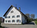
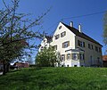
- In addition, the place still has some well-preserved historic farmhouses and houses, z. B .:
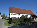
Dorfstrasse 19, Attenhausen
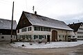
Dorfstrasse 32, Attenhausen

Kirchstrasse 8, Attenhausen

Kirchstrasse 8, Attenhausen
Mühlenweg 3, Attenhausen

Ottobeurer Str. 12, Attenhausen

Stephansrieder Str. 14, Attenhausen
Way to school 12, Attenhausen


literature
- Günther Städele, Hubert Strobel: Sontheim and Attenhausen. Pictures from the past . Ed .: Municipality of Sontheim. Geiger, Horb am Neckar 2003, ISBN 3-89570-895-X .
Web links
- Sontheim community
- Attenhausen in the location database of the Bayerische Landesbibliothek Online . Bavarian State Library
Individual evidence
- ↑ a b c d e f g h i j k l m n Städele, Strobel: Sontheim and Attenhausen . S. 110 .
- ↑ a b c d e Maximilian Dietrich (Ed.): The district of Memmingen . Maximilian Dietrich Verlag, Memmingen 1971, ISBN 3-87164-059-X , p. 136 .
- ↑ Prehistoric burial mounds on Luppberg in the Bavarian Monument Atlas (file number D-7-7927-0049)
- ^ Johann Nepomuk von Raiser : Chronicon antiquissimum Ottenburanum . Augsburg 1839, p. 7 ( Digitale-sammlungen.de [accessed on November 24, 2017]).
- ↑ With the exception of the sacristy built in 1993.
- ↑ See the context of the battle of Kammlach on August 13, 1796.
- ^ Günther Städele: 1150 years of Sontheim . Ed .: Municipality of Sontheim. Sontheim 1988, p. 72 .
- ↑ Städele, Strobel: Sontheim and Attenhausen . S. 147 .
- ↑ Städele, Strobel: Sontheim and Attenhausen . S. 137 .
- ↑ Städele, Strobel: Sontheim and Attenhausen . S. 150 f . (The dates there are not correct, it could either be the year 1860 or 1864.).
- ↑ Städele, Strobel: Sontheim and Attenhausen . S. 150 .
- ↑ Elly Heckelsmüller: Almost forgotten landmark becomes a monument . In: Memminger Zeitung . October 1, 2016.
- ↑ Kalkofen am Weiher in the Bavarian Monument Atlas (file number D-7-78-196-15)
- ↑ Städele, Strobel: Sontheim and Attenhausen . S. 131 .
- ↑ Städele, Strobel: Sontheim and Attenhausen . S. 138 .
- ^ Günther Städele: The end of the war in Sontheim in 1945 . Sontheim December 1985 (on Attenhausen in particular page 39, above).
- ↑ Städele, Strobel: Sontheim and Attenhausen . S. 140 .
- ^ Günther Städele: 1150 years of Sontheim . Ed .: Municipality of Sontheim. Sontheim 1988, p. 62 f .
- ^ Federal Statistical Office (ed.): Historical municipality directory for the Federal Republic of Germany. Name, border and key number changes in municipalities, counties and administrative districts from May 27, 1970 to December 31, 1982 . W. Kohlhammer, Stuttgart / Mainz 1983, ISBN 3-17-003263-1 , p. 782 .
- ^ Farewell to Father Robert Markovits. (No longer available online.) June 25, 2017, archived from the original on December 1, 2017 ; Retrieved November 25, 2017 . Info: The archive link was inserted automatically and has not yet been checked. Please check the original and archive link according to the instructions and then remove this notice.
- ↑ a b Maximilian Dietrich (Ed.): The district of Memmingen . Maximilian Dietrich Verlag, Memmingen 1971, ISBN 3-87164-059-X , p. 170 .
- ^ Community of Sontheim: Numbers-Data-Facts. Retrieved November 25, 2017 .