
Motorway 18 (Belgium)
| Motorway / Autoroute / Autosnelweg A18 in Belgium | ||||||||||||||||||||||||||||||||||

|
||||||||||||||||||||||||||||||||||
| |
||||||||||||||||||||||||||||||||||
| map | ||||||||||||||||||||||||||||||||||
.svg) |
||||||||||||||||||||||||||||||||||
| Basic data | ||||||||||||||||||||||||||||||||||
| Operator: | ||||||||||||||||||||||||||||||||||
| Overall length: | 44 km | |||||||||||||||||||||||||||||||||
| Development condition: | 2 × 2 lanes + emergency lanes | |||||||||||||||||||||||||||||||||
|
Course of the road
|
||||||||||||||||||||||||||||||||||
The Belgian motorway 18 , also on French. Autoroute 18 or Dutch Called Autosnelweg 18 , it starts at the French border at Adinkerke and ends in Jabbeke . Their total length is 44 km.
course
The A18 begins at the French border, where it merges from the A16 autoroute . It continues via Veurne and Gistel and crosses the N8 and N33 . At the Jabbeke junction , she joins the A10 , which continues to Brussels .
history
The A18 was divided into five sections during construction, which were completed between 1977 and 1997.
| section | opening |
|---|---|
| Jabbeke (A10) - Nieuwpoort | April 1, 1977 |
| Nieuwpoort - Oostduinkerke | 1989 |
| Oostduinkerke - Veurne | 1992 |
| Veurne - Adinkerke | 1996 |
| Adinkerke - French border | 1997 |
photos

A18 / E40 towards Veurne at the junction from the A10
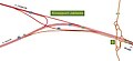
Scheme of the Jabbeke motorway triangle (A10 / A18)
.jpg)

Web links
Commons : A18 (Belgium) - Collection of images, videos and audio files