Azrou
| Azrou أزرو ⴰⵥⵕⵓ |
||||
|---|---|---|---|---|
|
||||
| Basic data | ||||
| State : |
|
|||
| Region : | Fès-Meknes | |||
| Province : | Ifrane | |||
| Coordinates | 33 ° 27 ′ N , 5 ° 13 ′ W | |||
| Residents : | 54,350 (2014) | |||
| Area : | 8.94 km² | |||
| Population density : | 6,079 inhabitants per km² | |||
| Height : | 1278 m | |||
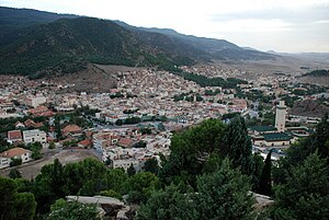
| View over Azrou to the southwest towards the valley exit - on the right the Great Mosque, behind the eponymous rock. The old town begins on the left edge of the picture. | ||||
Azrou (from the Maciric ⴰⵥⵕⵓ Aẓṛu , "rock", Arabic أزرو, DMG Azrū ) is a town with about 55,000 inhabitants in the Fès-Meknes region in northern Morocco . The historically important trading center of the Berbers was a summer resort due to its altitude in the mountains of the Middle Atlas during the French colonial period and is now a popular destination.
location
Azrou is a transport hub at the intersection of two highways. The national road 8 (route impériale) runs on the old caravan route from Fès in the north to Marrakech in the southwest along the western edge of the Middle Atlas. The national road 13 (route national) leads from the northwestern Meknès over the Atlas Mountains to the south over Midelt to Erfoud and ends at the Algerian border. The distances are 63 kilometers to Meknes, 80 kilometers to Fès via the small mountain town of Ifrane (17 kilometers) and 112 kilometers to Khénifra , the next larger town on the route to Marrakech.
The city is located at about 1250 m above sea level on the northern edge of a mountain area overgrown by cedars (Fôret de Cedres) . A side road leads 25 km through dense forest up into the mountains south to the Berber village of Ain Leuh (market day is on Wednesday) and 20 km further to the Oum er-Rbia waterfalls between limestone cliffs. This is the source of the country's longest year-round water-bearing river of the same name, which leaves the highlands to the southwest in a valley and later flows into the Atlantic through Khénifra and Kasba Tadla . Seven kilometers on the road towards Midelt, then on a path 4 km to the east, with a trunk circumference of ten meters and a height of 40 m, there is one of the world's largest cedars. Much wood from this area was used in the 19th century to build urban palaces and religious colleges ( madrasas ). Some lakes, cedar and oaks -Mischwälder and the chance Barbary apes to see make the mountains south of Azrou a popular hiking area.
Soft, rounded plateaus separated by valleys are typical of the Middle Atlas. Its height decreases from about 1800 m south of Azrou near Oum er Rbia to 1000 m near El-Hajeb 30 km north. The highest peak near Azrou is the basaltic volcanic cone of Jbel Hebri at 2104 m. With a snow line of 1500 m in winter, skiing is possible there. The average annual rainfall, which increases with altitude, is 827 millimeters in Azrou.
Population development
| year | 1994 | 2004 | 2014 |
|---|---|---|---|
| Residents | 40,408 | 47,540 | 54,350 |
The city's population consists almost exclusively of immigrant members of various Berber tribes from the area.
history
Azrou is an old trading post in the settlement area of the Berber tribe Beni Mguild . In the years 1057/58 the Almoravids under Ibn Yasin ended the regional rule of different Berber tribes under the influence of the Abbasid caliphate . The subsequent Berber dynasty of the Almohads conquered the Maghreb under their leader Abd al-Mu'min in the first half of the 12th century . Since 1139 his troops controlled the area south of Marrakech. From here they moved north through the Atlas Mountains and occupied Azrou. On the further way north, the capture of Sefrou and the siege of the old Idrisid capital Fez followed. In the centuries that followed, Berber dynasties fought repeatedly for power. In 1274 local tribal leaders revolted against the Merinids , who then besieged the city for a while.
The rule of the Alawids began in the 17th century. After the death of the Alavid Berber Mulai asch-Sharif (Mūlāy aš-Šarīf) of Sidschilmasa (1659), there was a succession dispute between his two sons Mulai ar-Raschid and Muhammad asch-Sharif , in which ar-Raschid emerged victorious . Ar-Raschid fled the southern Moroccan oasis city to ad-Dila, the ancestral seat of the Dila brotherhood (Dilāʾiyya) south of Khenifra in the Middle Atlas. He later moved to northeast Morocco, temporarily settling in Fez and in the Angad region , where he allied himself with the Arab Banu Maʿqil and the Berbers of the Ait Yaznasin. These tribes recognized ar-Raschid as sultan in 1663 . Meanwhile his brother had set up a base in Azrou. This closeness inevitably led to a conflict between the two. At the end of the year or the beginning of 1664, al-Sharif moved from Azrou to Angad, where he wanted to regain his lost power with the local tribes. But he was killed in battle. Ar-Raschid pushed the Dila brotherhood back from the plain into the Middle Atlas and was recognized a few years later as the founder of the Alawid Empire.
The borders of the empire on the Middle Atlas were repeatedly threatened by unrest and uprisings. In 1677 the followers of the Dila , who had been driven into exile in Tlemcen , returned and rebuilt their ancestral seat ( Zawiya ) . A few years later, further unrest forced the successor and half-brother of ar-Rashid, Mulai Ismail , to undertake military expeditions to the eastern border of his empire. In order to secure his sultan's power permanently, he had a number of fortified settlements ( kasbahs ) built or existing facilities expanded along the main route between Fès and Beni Mellal . In 1684 the Kasbah of Azrou was built on the edge of the Berber settlement. Mulai Ismail had set up special troops made up of black African slaves. Of this total of 70,000 men, around half remained near his capital Meknes, the others guarded the kasbahs and the smaller fortifications in between. During the 18th and 19th centuries there were several Berber attacks on the positions. The defeat of the Sultan's government ( Makhzen ) under Mulai Sulaiman in 1811 became known as the "Azrou Affair" .
With the treaty of March 30, 1912, which Sultan Mulai Abd al-Hafiz signed in Fès, Morocco became a French protectorate and French troops established themselves in the Fès-Meknes region. After the First World War , the French began to build a new town north of the existing settlement in Azrou in 1918, which was to serve as a summer resort. On the grounds of wanting to preserve the Berber culture, they set up five schools in the Atlas Mountains from 1923, in which the language of instruction was not Arabic but French. Berber dialects were not suitable for teaching. In 1929 the College d'Azrou was opened, which was attended by a tribal elite of the Beni Mguild. It was the first college in the Berber region. Few students were initially prepared here for the Dar El Baida military officers school in Meknes. The special Berber schools are related to the uprisings of the Arab nationalist upper class in the cities and were an attempt to split the population into two camps by Berber officers in the colonial forces. After independence, part of the country's political and military elite received their training here.
From 1952 to 1968 the Benedictine monastery of Tioumliline existed in the mountains near Azrou . In 1955, a large sanatorium for 400 patients with tuberculosis opened in the remote village of Ben Smim at 1,520 meters above sea level, ten kilometers from Azrou , but it was closed 20 years later (1975). After independence in 1956, the College d'Azrou was renamed Lycée Qualifiant Tarik Ibn Ziad in memory of the 8th century Berber leader Tāriq ibn Ziyād .
Cityscape
In the early 1970s the number of inhabitants was estimated at 6,000. The 1982 census showed 31,471 inhabitants, the 2014 census was 54,350 and 2013 was 53,868 inhabitants.
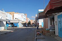
Azrou is located at the exit of a valley basin, which is surrounded on three sides by steep hills with patches of forest. A rock towering on the western edge of the town near the bus station gave the town its name. Nearby is the Great Mosque, completed in 1997 and financed by King Hassan II . Its minaret is 80 meters high, the entire building is covered with green glazed tiles and the exterior architecture is based on the huge Hassan II Mosque of Casablanca . In Morocco, green roof tiles are generally reserved for important buildings such as palaces, mosques and qubbas (mausoleums), in Azrou some residential buildings in the French colonial city are also covered with green roofs. The shops, hotels, cafes and restaurants of this new town are lined up in the bottom of the valley about 300 meters east of the mosque around the central Place Mohammed V. Directly south are the narrow streets of the market ( Suq ) , the simple, recently built houses the former old town ( Medina ) continue to the south, sometimes steeply up the mountain. There is practically nothing left of the old town and only remnants of the kasbah have survived.
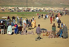
Since the end of the 20th century, a new, much larger urban settlement has been built half a kilometer north of the market. Uniform rows of houses are erected in rectangular squares of streets, which extend between the fields in the plain. It's 1.5 kilometers in this direction along Boulevard Moulay Abdelkader to the weekly market, where every Tuesday the Berbers in the area sell carpets, woolen blankets, cedar carvings, household goods and groceries. Handicrafts are also offered daily in the Center Artisanal , which is located on Boulevard Mohammed V a little southwest of the medina on the road to Khénifra . The craftsmen try to adapt their production to the wishes of the tourists.
In July 2016, a cultural center ( Center Culturel d'Azrou ) with a permanent ethnographic exhibition was opened in Azrou .
Web links
- Azrou. Cedars and Green Tiles. LookLex
Individual evidence
- ↑ Population statistics Morocco ( Memento from July 1, 2016 in the Internet Archive )
- ↑ Azrou - climate tables
- ↑ Azrou - population development
- ^ Jamil M. Abun-Nasr: A history of the Maghrib in the Islamic period. Cambridge University Press, Cambridge 1987, p. 229
- ↑ Pierre Vermeren: The North African educational challenge: From colonization to the current alleged Islamist thread. (PDF; 47 kB) In: Mediterranean Journal of Educational Studies, Vol. 14, No. 2, University of Malta 2009, p. 53
- ↑ http://www.redasociativa.org/dosorillas/modules.php?name=News&file=article&sid=196 (dead link)
- ^ Helmut Aschbacher: Morocco. Goldstadt, Pforzheim 1976, p. 96
- ↑ http://bevoelkerungsstatistik.de/wg.php?x=&men=gpro&lng=de&des=wg&srt=npan&col=abcdefghinoq&msz=1500&geo=444437477 (dead link)
- ↑ Wadii Bellamine, Marouane Afiri: The Impact of Globalization on Small Scale Artisans in Azrou, Morocco. (PDF; 1.8 MB) An Interactive Qualifying Project. (Bachelor Degree) Worcester Polytechnic Institute, 2007


