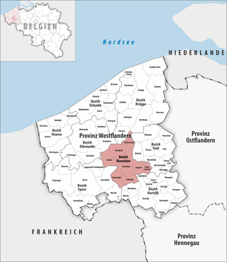
Roeselare district
| Roeselare district | |
|---|---|
| region | Flanders |
| province | West Flanders |
| Residents | 153,315 (Jan 1, 2019) |
| Population density | 565 inhabitants / km² |
| surface | 271.54 km² |
| Communities | 8th |
| NIS code | 36000 |
 Location of the district of Roeselare in the province of West Flanders |
|
The district of Roeselare is one of eight administrative arrondissements in the Belgian province of West Flanders . It covers an area of 271.54 km² with 153,315 inhabitants ( as of January 1, 2019 ) in eight municipalities.
The judicial district of the municipalities of Staden and Moorslede is the district of Ypres , for the municipality of Lichtervelde the district of Bruges and for the other municipalities the district of Kortrijk .
Municipalities in the Arrondissement of Roeselare
| local community | Residents January 1, 2019 |
Area km² |
Density of population / km² |
NIS code |
Post Code |
|---|---|---|---|---|---|
| Hooglede | 9,987 | 37.84 | 264 | 36006 | 8830 |
| Ingelmunster | 10,996 | 16.16 | 680 | 36007 | 8770 |
| Izegem | 28,018 | 25.48 | 1,100 | 36008 | 8870 |
| Ledegem | 9,695 | 24.76 | 392 | 36010 | 8880 |
| Lichtervelde | 8,926 | 25.93 | 344 | 36011 | 8810 |
| Moorslede | 11,250 | 35.34 | 318 | 36012 | 8890 |
| Roeselare | 62,954 | 59.79 | 1,053 | 36015 | 8800 |
| Staden | 11,489 | 46.24 | 248 | 36019 | 8840 |
| Roeselare district | 153.315 | 271.54 | 565 | 36000 | - |
See also
Individual evidence
- ↑ Mouvement de la population par commune depuis 1992 (XLSX; 2.56 MB)
- ↑ Indeling van de gemeenten volgens administratieve enerechtelijke arrondissementen ( Memento of December 2, 2013 in the Internet Archive ) (PDF; 283 kB)