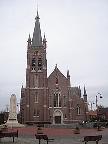
Lichtervelde
| Lichtervelde | ||
|---|---|---|

|

|
|
|
|
||
| State : |
|
|
| Region : | Flanders | |
| Province : | West Flanders | |
| District : | Roeselare | |
| Coordinates : | 51 ° 2 ′ N , 3 ° 8 ′ E | |
| Area : | 25.93 km² | |
| Residents: | 8926 (Jan. 1, 2019) | |
| Population density: | 344 inhabitants per km² | |
| Post Code: | 8810 | |
| Prefix: | 051 | |
| Mayor: | Ria Beeusaert-Pattyn | |
Local government address : |
Gemeentehuis Marktplaats 2 8810 Lichtervelde |
|
| Website: | www.lichtervelde.be | |
Lichtervelde is a Belgian municipality in the Flanders region with 8926 inhabitants (as of January 1, 2019).
Torhout is 4 km north, Roeselare 9 km south, Bruges 20 km north, Kortrijk 23 km south-southeast, Ghent 40 km east and Brussels about 86 km south-south-east.
The next motorway exit is at the “Lichtervelde” junction on the A17. Lichtervelde has a regional train station on the Kortrijk – Lichtervelde – Bruges and Veurne - Diksmuide –Lichtervelde – Tielt –Gent lines. Interregional express trains also stop in the cities of Ostend , Bruges and Ghent. There is a regional airport near Ostend and an international airport near Brussels.
Web links
Commons : Lichtervelde - collection of images, videos and audio files

