
Oostkamp
| Oostkamp | |||
|---|---|---|---|

|

|
||
|
|||
| State : |
|
||
| Region : | Flanders | ||
| Province : | West Flanders | ||
| District : | Bruges | ||
| Coordinates : | 51 ° 9 ' N , 3 ° 14' E | ||
| Area : | 79.65 km² | ||
| Residents: | 23,698 (Jan. 1, 2019) | ||
| Population density: | 298 inhabitants per km² | ||
| Post Code: | 8020 | ||
| Prefix: | 050 | ||
| Mayor: | Jan de Keyser ( CD&V ) | ||
| Website: | www.oostkamp.be | ||

Oostkamp is a municipality in the province of West Flanders , Belgium. The community has 23,698 inhabitants (as of January 1, 2019).
In the past, Oostkamp has always been characterized by its green character with lots of forests, open landscapes and the pleasant village center. In recent years some of it has been lost due to industrial buildings.
geography

Districts
- Oostkamp (I)
- Hertsberg (II)
- Ruddervoorde (III)
- Waardamme (IV)
The districts of Hertsberge, Ruddervoorde and Waardamme were incorporated into Oostkamp in 1977.
_-_Town_hall.jpg)
Neighboring communities
The following cities and municipalities border Oostkamp:
- Bruges (a and b)
- Beernem (c and d)
- Wingene (e and f)
- Lichtervelde (g)
- Torhout (h)
- Zedelgem (i and j)
Attractions
- Worth seeing is the Sint-Pieterskerk ( Saint Peter in Chains ), a three-aisled hall church with Romanesque tower of the 12th century and an organ from 1717. It stands as well as the town hall under monument protection .
- There are various neo-renaissance castles in the area , including Pecsteen in Ruddervoorde (also listed).
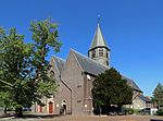
Sint-Pieterskerk
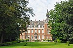
Pecsteen Castle


Town twinning
Sister cities of Oosterkamp are:
- Chaumont , France
- Bad Langensalza , Germany
- Bad Nauheim , Germany
Web links
- Website of the municipality (Dutch)
proof
- ↑ Jan De Keyser. Gemeente Oostkamp, accessed May 24, 2017 (Dutch).
- ^ Parochiekerk Sint-Pieters-in-de-banden - inventaris bouwkundig erfgoed
- ↑ Gemeentehuis van Oostkamp - inventaris bouwkundig erfgoed
- ↑ Kasteel Pecsteen - inventaris bouwkundig erfgoed
- ↑ VVSG-Internationaal: Jumelages in Vlaanderen
Alveringem | Display | Ardooie | Avelgem | Beernem | Blankenberge | Bredene | Bruges | Dam | De Haan | De Panne | Deerlijk | Dentergem | Diksmuide | Gistel | Harelbeke | Heuvelland | Hooglede | Houthulst | Ichtegem | Ingelmunster | Izegem | Jabbeke | Knokke-Heist | Koekelare | Koksijde | Kortemark | Kortrijk | Kuurne | Langemark-Poel Chapel | Ledegem | Lendelede | Lichtervelde | Lo-Reninge | Menen | Mesen | Meulebeke | Middelkerke | Moorslede | Nieuwpoort | Oostkamp | Oostrozebeke | Ostend | Oudenburg | Pittem | Poperinge | Roeselare | Ruiselede | Spiere-Helkijn | Staden | Tielt | Torhout | Veurne | Vleteren | Waregem | Wervik | Wevelgem | Wielsbeke | Wingene | Ypres | Zedelgem | Zonnebeke | Zuienkerke | Zwevegem