
Gmina Biały Dunajec
| Gmina Biały Dunajec | |||
|---|---|---|---|

|
|
||
| Basic data | |||
| State : | Poland | ||
| Voivodeship : | Lesser Poland | ||
| Powiat : | Tatrzański | ||
| Geographic location : | 49 ° 22 ' N , 20 ° 1' E | ||
| Residents : | see Gmina | ||
| Postal code : | 34-425 Biały Dunajec | ||
| Telephone code : | (+48) 18 | ||
| License plate : | KTT | ||
| Economy and Transport | |||
| Street : | DK 47 | ||
| Rail route : | Chabówka – Zakopane | ||
| Gmina | |||
| Gminatype: | Rural community | ||
| Surface: | 35.51 km² | ||
| Residents: | 7198 (June 30, 2019) |
||
| Population density : | 203 inhabitants / km² | ||
| Community number ( GUS ): | 1217022 | ||
| Address: | ul.Jana Pawła II 312 34-425 Biały Dunajec |
||

The Gmina Biały Dunajec is a rural municipality in the powiat Tatrzański of the Lesser Poland Voivodeship in Poland . Your seat is the village of the same name with about 4200 inhabitants.
The municipality is located in the historical Podhale region . The Biały Dunajec belongs to the waters .
structure
The rural community (gmina wiejska) Biały Dunajec includes the following villages with a school administration (sołectwo):
Biały Dunajec, Gliczarów Dolny , Gliczarów Górny , Sierockie and Leszczyny .
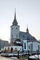
St. Mary's Church in Biały Dunajec

Individual evidence
- ↑ population. Size and Structure by Territorial Division. As of June 30, 2019. Główny Urząd Statystyczny (GUS) (PDF files; 0.99 MiB), accessed December 24, 2019 .
Web links
Commons : Gmina Biały Dunajec - collection of images, videos and audio files