Bosonohy
| Bosonohy | ||||
|---|---|---|---|---|
|
||||
| Basic data | ||||
| State : |
|
|||
| Region : | Jihomoravský kraj | |||
| District : | Brno-město | |||
| Municipality of: | Brno | |||
| Area : | 715 ha | |||
| Geographic location : | 49 ° 11 ' N , 16 ° 32' E | |||
| Height: | 270 m nm | |||
| Residents : | 2,362 (May 14, 2007) | |||
| Postal code : | 642 00 | |||
| License plate : | B. | |||
| traffic | ||||
| Street: | Brno - Rosice | |||
| Next international airport : | Brno-Turany Airport | |||
| structure | ||||
| Status: | Borough | |||
| Districts: | 1 | |||
| administration | ||||
| Mayor : | Miroslav Sojka (as of 2009) | |||
| Address: | Bosonožské nám. 1 642 00 Brno-Bosonohy |
|||
| Website : | www.bosonohy.cz | |||
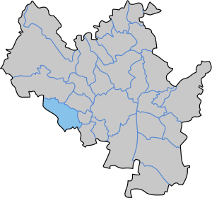
| Location of Bosonohy in the Brno-město district | ||||

|
||||
Bosonohy (German Parfuss ) is a district of Brno in the Czech Republic . It is located six kilometers southwest of the city center of Brno on the western outskirts and belongs to the Okres Brno-město .
geography
Bosonohy is located in the Troubsko-střelická kotlina at the transition from the northwestern foothills of the Thaya-Schwarza valley basin to Bobravská vrchovina . The village lies on the Leskava brook. The Kohoutovická Baba (415 m) rises to the north and the Hradisko (333 m) to the northwest. The D1 / E 55 / E 65 motorway runs south of the village , the next exit 190 Brno-zapad is a good one and a half kilometers southeast of the village.
Neighboring towns are Kohoutovice in the north, Stránice and Pisárky in the northeast, Nový Lískovec, Bohunice and Starý Lískovec in the east, Ostopovice in the southeast, Troubsko in the south, Veselka and Popůvky in the west and Žebětín in the northwest.
history
The first written mention of Bosonohy was in a document from Wenceslas I from 1237, in which he bought the Bosonohy estate in exchange for the Medlany, Březovice and Vážany farms to Zdislav, the pleban of the Church of St. Peter , to compensate for war damage suffered left. According to older traditions, the founder of the Cistercian monastery "Vallis Sanctae Mariae" in Oslavany , Heilwida von Znaim, left her property and a vineyard in Bosonohy to the Benedictine order in 1225.
During the siege of Brno by Torstensson in 1645, the Swedes roamed the dense forest areas around the city in search of food for the troops. Bosonohy was also looted.
After the abolition of patrimonial Bosonohy formed a municipality in the Brno district from 1850. In 1921 Bosonohy came to the Okres Brno-venkov. Between 1930 and 1937, east of Bosonohy, the start and finish of the circuit of the 29.1 km long Brno Ring, which was named Masaryk Ring in honor of President Tomáš Garrigue Masaryk , was located. The old route led through the village into the forest area Podkomorské lesy via Ostrovačice and Žebětín back to Bosonohy. During the Second World War, from 1942 to 1944, Bosonohy was the hideout of General Vojtěch Luža , who had set up a partisan unit in the woods.
In 1948 the municipality Bosonohy was assigned to the Okres Brno-okolí. After its abolition, Bosonohy came back to Okres Brno-venkov in 1961. At the end of the 1960s, a cadastral settlement with the city of Brno was carried out, in which northern parts of the municipal area of the city were added. On November 26, 1971 the incorporation to Brno took place . Between 1976 and 1990 Bosonohy was part of the Brno I district. The Bosonohy district was established on November 23, 1990. In 1991 Bosonohy had 2137 inhabitants. In 2001, 2,210 people lived in the 633 houses in the village.
Partner municipality
- Abbadia Lariana , Italy, since 2002
Attractions
- Chapel of St. Florian on the village square, built in 1713. In 1753 the chapel received an organ, which was replaced in 1864. In 1864 it was rebuilt and enlarged.
- Prayer pillar
- Bosonožský hájek nature reserve, northwest of the village
Sons and daughters of the place
- Vojtěch Cikrle (* 1946), Bishop of Brno


