Bottendorf (Roßleben-Wiehe)
|
Bottendorf
City and rural community of Roßleben-Wiehe
|
|
|---|---|
| Coordinates: 51 ° 18 ′ 14 " N , 11 ° 24 ′ 14" E | |
| Height : | 125 m above sea level NN |
| Area : | 11 km² |
| Residents : | 1228 (Jan. 30, 2006) |
| Population density : | 112 inhabitants / km² |
| Incorporation : | April 1, 1999 |
| Incorporated into: | Rossleben |
| Postal code : | 06571 |
| Area code : | 034672 |
|
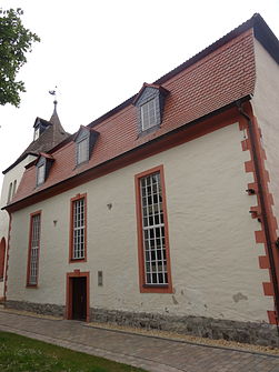
Village church
|
|
Bottendorf is part of the urban and rural community of Roßleben-Wiehe in the Kyffhäuserkreis in Thuringia .
location
Bottendorf is on the border with Saxony-Anhalt on the banks of the Unstrut in the valley between Finne and Ziegelrodaer Forst. The Bottendorfer Hills are a nature reserve.
history
In a register of the tithe of the Hersfeld monastery , which was created between 881 and 899, Bottendorf is mentioned for the first time in a document as Budilendorpf im Friesenfeld, which is subject to a tenancy requirement . Before 1050 there was a moated castle in the area of today's district “Old City” between two arms of the Unstrut. After 1050 to 1085, the former castle is said to have been replaced by the New Castle. The second arm of the Unstrut is filled, but still detectable. Remnants of fastening are no longer recognizable.
Until 1815 Bottendorf was in the Saxon office of Wendelstein .
On April 1, 1999 Bottendorf was incorporated into Roßleben. This in turn has been part of the urban and rural community of Roßleben-Wiehe since January 1, 2019.
coat of arms
The coat of arms was approved on February 3, 1994.
Blazon : "In silver, a left-turning, red-armored blue eagle, covered with a silver heart shield, inside a red carnation."
With the eagle as the main motif, a coat of arms of the Saxon Count Palatine Friedrich von Putelendorf is used. According to Ernst Brotuff's “Chronica und Antiquitates von Marsburg” in 1557, they carried a blue eagle turned to the left in silver. Two generations of the Count Palatine, Friedrich III. and Friedrich IV. von Putelendorf, with their names refer to the original name of Bottendorf and had their castle, the Putelenburg, in the current location. The red carnation in the silver heart sign symbolizes the Bottendorf carnation (Armeria maritima ssp. Bottendorfensis), which is also called grass or mountain carnation. This otherwise very rare plant belongs to the flora of the communal corridor.
The coat of arms was designed by the heraldist Michael Zapfe .
economy
Agriculture and handicrafts are predominant. Bottendorf had its economic peak in the 15th to 18th centuries, when copper slate mining was still carried out. Because of the copper smelter , the Unstrut was used as a waterway and expanded accordingly. Today there is a lot of sport boat traffic here.
Personalities
- Richard Hüttig (1908–1934), communist and fighter against fascism
- Johannes Steinhoff (1913–1994), fighter pilot in World War II and four-star general in the Bundeswehr
Attractions
- Windmill
- "Old ferry ditch"
- Old copper works
- St. Mauritius Church
- Stele of a gypsy prince in the cemetery
- Bottendorfer mountain grass carnation ("Armeria maritima bottendorfensis")
- Memorial plaque at the school in memory of the communist resistance fighter Richard Hüttig , who was murdered in Berlin-Plötzensee in 1934
literature
- Siegfried Schumann: The old copper mines in Bottendorf . WiKu-Verlag Verlag for Science and Culture 2005. ISBN 978-3-86553-134-6
- Siegfried Schumann: The history of the Saxon count palatine .
- Siegfried Schumann: Under the spell of Troy castles, holy stones and places of worship .
- Johannes Leipold: Chronicle of the copper slate mining in Bottendorf . 1st edition. Rockstuhl Verlag, Bad Langensalza 2007. ISBN 978-3-938997-67-3
Web links
Individual evidence
- ↑ Michael Köhler: Thuringian castles and fortified prehistoric and protohistoric living spaces , Jenzig-Verlag, 2001, ISBN 3-910141-43-9 , p. 58
- ↑ StBA: Changes in the municipalities in Germany, see 1999
- ^ New Thuringian Wappenbuch Volume 2, page 23; Publisher: Arbeitsgemeinschaft Thüringen eV 1998 ISBN 3-9804487-2-X


