Brunnenviertel
The fountain area is a residential district in the Berlin district of Gesundbrunnen the Mitte district . It is located between Bernauer Strasse and Berlin Gesundbrunnen train station on both sides of Brunnenstrasse . The quarter is bordered on three sides by former or still operating railway systems: In the north by the ring railway ; in the east of the former tracks and the embankment of the Berlin Northern Railway , which from 1961 to 1989 represented the border of the Berlin Wall and are now used as Mauerpark ; in the west, finally, from the former railway facilities of the Stettiner Bahn , also a border facility at the time of the Berlin Wall, on whose grounds the park at the Nordbahnhof is today.
history


The area of today's Brunnenviertel was used for agriculture until the 19th century. Street names such as Ackerstrasse and Gartenstrasse are tangible evidence of this today. The place of execution with the gallows outside the city was also located there - it was last used in 1837.
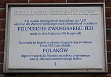
With the industrial development, inexpensive living space had to be created for the industrial workers. ( AEG settled on Brunnenstrasse; a center for locomotive construction was established in Liesenstrasse with the iron foundry and machine factory of L. Schwartzkopff ). The quarters were of a very basic standard, there was no bathroom and the toilet was halfway up the stairs. An outstanding example of the living conditions in this socially very difficult district was " Meyers Hof " in Ackerstrasse 132/133, a tenement with six backyards , until it was demolished in 1972 .
The Berlin Senate finally declared the Brunnenviertel to be a redevelopment area and had spacious new buildings built with lifts, dining areas and large balconies. Some of the former residents were moved to the Märkisches Viertel . The reorganization of the quarter met with mixed feedback: the new residents were satisfied to finally move into spacious apartments with lots of greenery in the courtyards with their children, and many young people protested because the old housing stock had offered them cheap living space and thus independence. The population structure later changed again with the arrival of migrants .
Since 1999 there has been a district management that works with residents to develop ideas for the development of the district. As part of this work, after surveys among the residents, the name "Brunnenviertel" was selected for the area that was not explicitly named up to then. Its acceptance is reflected in the widespread assumption that the district has always been called that.
Attractions
- Examples of industrial architecture are the old factory buildings of Siemens and AEG, which today serve as office and commercial space in the technology and innovation park . Deutsche Welle and the departments of the Technical University have settled here alongside others . At the intersection of Liesenstrasse / Gartenstrasse / Ackerstrasse / Scheringstrasse and Rechtsstrasse, the old steel trussed railway bridge can be viewed, over which the completed locomotives left the factory. The listed Gleim tunnel is also worth seeing .
- As churches, St. Sebastian as the third largest house of God in Berlin and the Church of Peace Zum Heiligen Sava are worth mentioning.
- The Berlin Wall memorial ensemble is located along Bernauer Strasse on the former border strip between Brunnenstrasse and Gartenstrasse .
- The three mainly used green spaces in this area are the Volkspark Humboldthain, built in 1869 in the north between Gustav-Meyer-Allee, Brunnenstrasse and the railway line , the Mauerpark , which has been built since 1992 , which is laid out on the former railway facilities of the Nordbahn and the border strip of the Berlin Wall as well as the park opened in 2009 at the Nordbahnhof .
Web links
- Brunnenviertel online. Portal of Brunnenviertel e. V.
- Brunnenviertel . In: District lexicon of the Luisenstädtischer Bildungsverein
- Brunnenviertel / Marthashof: The “social equator” as a new frontier
Coordinates: 52 ° 33 ' N , 13 ° 24' E


