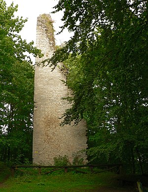
Wohlenstein castle ruins
| Wohlenstein castle ruins | ||
|---|---|---|
|
The donjon as the last remains of the Wohlenstein Castle |
||
| Alternative name (s): | Woldenstein, Wohldenstein | |
| Creation time : | 1295 | |
| Castle type : | Hilltop castle | |
| Conservation status: | ruin | |
| Place: | Imagery | |
| Geographical location | 51 ° 53 '45 " N , 10 ° 6' 57" E | |
| Height: | 253 m above sea level NN | |
|
|
||
The Wohlenstein castle ruins , sometimes also called Woldenstein or Wohldenstein , was a smaller hilltop castle above Bilderlahe in the Goslar district in Lower Saxony . Today's castle ruins only consist of the partially preserved keep .
location
The remains of the castle are located 253 m above sea level. NHN on the Wohlenstein hill of the same name, a conical extension of the Heber . The system dominated the passing Heerstraße Frankfurt am Main - Braunschweig , which entered the Ambergau about 7 km further north . From the castle, the entire area around the Seesen, 4 km to the east, was clearly visible.
Building description

The castle square has an oval shape measuring 45 x 15 m, which was divided into two areas. At the keep was a gate tower that led from the outer bailey into the inner bailey. On a historical representation, the installation comprises the components keep, gate tower and Palas , wherein walls are missing. The only structural remains of the castle are only three sides of the once 24 m and now 18 m high keep, which has almost 3 m thick walls. On the outside, the complex had a double moat and defensive wall system , of which the outer wall and the deep moat are still preserved today. The depth of the trench is more than 10 meters from the top of the wall. It is believed that the original access to the castle was through the rampart in the north and that after the castle was destroyed in 1519, a new access route to the south towards the Bilderlahe was created.
There are two historical representations of the castle. The older one can be found on the grave slab of Hildesheim Bishop Heinrich III. who acquired the castle in 1357. It depicts the castle around 1363. Another representation can be found on a map made by Johannes Krabbe in 1591 , which shows the castle in 1520 during the Hildesheim collegiate feud .
history
The castle was built in 1295 by a branch of the Wohldenbergers , with the abbess of the Gandersheim monastery acting as liege mistress. In 1357 it fell to the Bishop of Hildesheim . In 1349 the Wohldenbergers sold the castle to the noblemen of Homburg . In 1357, Bishop Heinrich III. of Hildesheim the castle. At the beginning of the 16th century, Duke Erich I von Calenberg-Göttingen besieged the castle at the beginning of the Hildesheim collegiate feud due to multiple feudal feuds and property disputes. He took the facility, which was only occupied by 15 men, on May 30, 1519 and completely destroyed it. After the collegiate feud, the castle and the Wohlenstein office went to Duke Heinrich the Younger of Braunschweig-Wolfenbüttel . He moved the administration from the castle down to the newly built office building in Bilderlahe. The bricks of the castle were used for the Heber Vorwerk and the farm buildings of the Bilderlahe domain .
literature
- Ernst Andreas Friedrich : If stones could talk. Volume IV, Landbuch-Verlag, Hannover 1998, ISBN 3-7842-0558-5
- Margret Zimmermann, Hans Kensche: Castles and palaces in Hildesheimer Land . Hildesheim, 2001, pp. 14-15
- Thomas Küntzel: Twisted Castle. Wohlenstein Castle near Seesen in: Archeology in Lower Saxony , pp. 95–98, 2013
Web links
- Entry by Stefan Eismann zu Wohlenstein in the scientific database " EBIDAT " of the European Castle Institute
- Castle description on the website of Bilderlahe
- Description with floor plan at burgenwelt.de
- Historical reconstruction drawing

