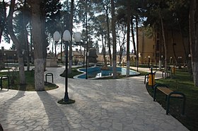
Ceylanpınar
| Ceylanpınar | ||||
|
||||
 city Park |
||||
| Basic data | ||||
|---|---|---|---|---|
| Province (il) : | Şanlıurfa | |||
| Coordinates : | 36 ° 51 ' N , 40 ° 3' E | |||
| Height : | 398 m | |||
| Residents : | 43,718 (2008) | |||
| Telephone code : | (+90) 414 | |||
| Postal code : | 63570 | |||
| License plate : | 63 | |||
| Structure and administration (status: 2009) | ||||
| Mayor : | İsmail Arslan ( BDP ) | |||
| Website: | ||||
| Ceylanpınar County | ||||
| Residents : | 71,272 (2008) | |||
| Surface: | 2,001 km² | |||
| Population density : | 36 inhabitants per km² | |||
| Kaymakam : | Musa Uslan | |||
| Website (Kaymakam): | ||||
Ceylanpınar (formerly Ottoman رأس العين Rasüleyn , Kurdish سەرێ کانیێ Serê Kaniyê ) is a city and at the same time the name of a district in the Turkish province of Şanlıurfa in southeastern Anatolia .
The city of Ceylanpınar has 43,718 inhabitants (2008). It is located directly on the Syrian border and on the Baghdad Railway, opposite Raʾs al-ʿAin . It is not possible to cross the border between the two cities.
71,272 inhabitants are given for the district (as of 2008). It runs 142 kilometers along the Syrian-Turkish border. In the west, Ceylanpınar borders on the province of Mardin . Ceylanpınar has been an independent district since January 1982.
history
By the end of World War Ceylanpınar and Ras al-Ayn were a single city, then through the demarcation split was. Early history was unearthed one kilometer south of the present city in Tell Fecheriye . The finds there prove a settlement from the beginning of the 2nd millennium BC. Through the empire of Mitanni , the Central and New Assyrian empire and up to the Islamic period around 800 AD.
In Roman times the place was called Resaina and was in the east of the ancient landscape of Osrhoene . The name derives from coin finds, texts by ancient authors and the entry on the Tabula Peutingeriana , a late Roman map. Under Theodosius I (347–395) the place was re-established as Theodosiopolis , received city rights in 383 and was a bishopric.
In the Roman-Persian wars under the Roman emperor Gordian III. the first attack by Shapur I repulsed in 243 at the battle of Resaina, so that the Sassanids had to retreat behind the Euphrates . At the end of the 6th century, the Persian general Adharmahan destroyed the city twice during the reign of Hormizd IV .
Ceylanpınar was conquered by the Islamic Arabs in 640 . In the 10th century, Byzantines briefly occupied the city and sacked it. During the crusades in the 12th century it was conquered by Joscelin I , a large part of the Arab population was killed or led into slavery.
The city was under the rule of the Zengids from the middle of the same century and, towards the end, under their successors, the Ayyubids . The conqueror Timur sacked the city in the 14th century. In the 16th century the region became part of the Ottoman Empire . The present city was re-founded in 1878 by Circassians who had been driven from the Caucasus .
After the First World War , Ceylanpınar was divided. The southern part became part of the League of Nations mandate for Syria and Lebanon , while the northern part became Turkish. The Arabic name Resülayn was Turkishized to Ceylanpınar .
Web links
Individual evidence
- ↑ a b Turkish Institute for Statistics ( Memento from December 5, 2012 in the web archive archive.today ), accessed November 26, 2009


