
Birecik
| Birecik | ||||
|
||||
| Basic data | ||||
|---|---|---|---|---|
| Province (il) : | Şanlıurfa | |||
| Coordinates : | 37 ° 2 ' N , 37 ° 59' E | |||
| Height : | 450 m | |||
| Residents : | 48,706 (2012) | |||
| Telephone code : | (+90) 414 | |||
| Postal code : | 63 xxx | |||
| License plate : | 63 | |||
| Structure and administration (as of 2020) | ||||
| Mayor : | Mahmut Mirkelam ( AKP ) | |||
| Website: | ||||
| Birecik district | ||||
| Residents : | 94,277 (2017) | |||
| Surface: | 790 km² | |||
| Population density : | 119 inhabitants per km² | |||
| Kaymakam : | Mehmet Fatih Koca | |||
| Website (Kaymakam): | ||||

Birecik , the old Birtha ( Syriac-Aramaic for palace), is a district ( İlçe ) and municipality of the province of Şanlıurfa in southeastern Turkey near the border with Syria . The Kurdish name is Bêrecûg , the Arabic al-Bīrā البيراand the French from the time of the County of Edessa Bile . In ancient times the city was called Makedonopolis . Birecik is located on the Euphrates , over which the D400 expressway runs on the second longest river bridge in Turkey, built in 1956, and on Otoyol 52 , about halfway between Gaziantep and Şanlıurfa (Edessa).
Administration and population
_-_panoramio.jpg)
Since the territorial reform of 2012, the city of Şanlıurfa has been a Büyükşehir Belediyesi , which is identical to the province ( İl ) in terms of area and population . As such a metropolitan commune, it represents the municipal administrative level of the provincial districts. In the course of an administrative reform of the province, the central district ( Merkez ) was divided into three new districts in 2014 , and the former districts of the province were thus divided into 13 districts. They also represent urban districts whose municipal administration is directly subordinate to the Büyükşehir Belediye Başkanı (Lord Mayor) of Şanlıurfa. The state administration is still represented by the provincial governor ( Vali ) , to whom the İlçe Kaymakam reports. The administrative area of the İlçes corresponds territorially to the former municipalities (Belediye) , whose mayors were downgraded by the Başkan to the rank of Muhtar . As a district, the former district town of Birecik has three parish towns, 69 villages and 84 settlements. Birecik itself had 48,706 inhabitants in 2012. The majority of the population is Muslim . Up to the First World War , about 20% of the population were Christians , about a third of them Armenians . In 1895 a pogrom against this ethnic group took place here too. As Birtha , Birecik was the titular bishopric of the Roman Catholic Church until 1977 . One of the larger Yazidi communities in Turkey lived in Birecik until the wave of emigration in the 1980s .

history
It is not known who built the White Fortress of Birecik (Arabic: Qal'at ul-Baydha , Turkish: Beyaz Kale ) on a limestone rock on the east bank of the Euphrates at a ford . It was under the Romans (30 BC to 395 AD), the Crusaders (also called Franks here , 1098 AD to 1150 AD) and the Mamluks (1277 AD to 1484 AD) expanded a total of three times. The fortress, which is considered impregnable, was badly damaged by several earthquakes. According to a historical inscription, it was first renovated at the beginning of the 13th century by az-Zahir Ghazi , the ruler of Aleppo . As al-Bira , Birecik was one of the three districts of the Euphrates region in the Syrian border protection system al-thughūr wa-l-'awāṣim against the Turkish empires. In 1405 Birecik was sacked by the troops of Qara Yoluq Osman Bey .

archeology
9 km from Birecik is part of the Southeast Anatolia project, the Birecik reservoir . The ancient city of Apamea on the Euphrates was flooded on its east bank, and the Roman ancient city of Zeugma on the west bank . Some rescued exhibits from Zeugma are exhibited in Birecik today, the famous mosaics, including that of the river god Acheloos , can be viewed in the Zeugma Mosaic Museum in Gaziantep . In the hill Hacınebi ( Hacınebi Höyüğü ) located 4 km to the north , in historical times a crossing point of two major trade routes, excavations since 1992 have found evidence of settlement layers that go back to the Copper Age. The work is carried out by the Şanlıurfa Archaeological Museum and Northwestern University , USA . Excavations have been carried out on the Fıstıklı Höyük settlement mound 3 km to the south since 1989. Traces of settlement up to the Chalcolithic period were also found in Mezraa-Teleilat , 4 km south . With its rich architectural heritage, Birecik is a member of the European Association of Historic Towns and Regions (EAHTR) , founded in 1999 and based in Norwich .
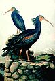
Waldrapp population
For a long time, the last known free population of the bald ibis ( Geronticus eremita , Turkish: Kelaynak , regionally also Keçelaynak ) lived in Birecik in the east Mediterranean area , until another small population was discovered in Syria in 2002. Today a rearing and protection station is operated for the ibis birds placed under species protection . The Waldrapp reserve was on the tentative list as a World Heritage candidate from 1984–1996 . The bald ibis appears in the biblical story of Noah's Ark , in which after the end of the Flood it led Noah from Mount Ararat down into the valley to the upper Euphrates, where Noah and his family settled down. For this reason, the bald ibis was protected as a sacred animal in the Birecik area and honored with annual festivals.
gallery

Bridge over the Euphrates
Waldrapp, drawing by Naumann

Migration map of the bald ibis

man-made nesting sites of a bald ibis colony

Bald ibis


sons and daughters of the town
- Mehmet Akan (1939–2006), actor, director, choreographer, folklorist and writer
- Ahmed Ateş (1911–1966), orientalist and researcher of Persian literature
- Feridun Ayalp (1916–1979), politician ( Democrat Parti )
- Ferhat Çulcuoğlu (* 1987), football player
- Ahmet Eşref Fakıbaba (* 1951), politician ( Adalet ve Kalkınma Partisi )
- Ferhat Göçer (* 1970), surgeon and pop and opera singer
- Necdet Karababa (* 1935), politician ( Democracy Sol Parti )
- Cemal Orhan Mirkelam (1924–2009), bureaucrat
- Necip Mirkelamoğlu (1922–2010), bureaucrat, politician and composer ( Cumhuriyet Halk Partisi )
- Zühal Topçu (* 1960), politician ( Milliyetçi Hareket Partisi )
See also
Web links
Individual evidence
- ↑ a b Turkish Institute for Statistics (TUIK). Retrieved January 12, 2019 .
- ↑ Birejik . In: Encyclopædia Britannica . 11th edition. tape 3 : Austria - Bisectrix . London 1910, p. 979 (English, full text [ Wikisource ]).
- ↑ Gernot Wießner: "... wandered into the killing light of a strange world" . In: Robin Schneider (Ed.): The Kurdish Yezidi. A people on the way to doom . Pogrom 110. Society for Threatened Peoples, Göttingen 1984. ISBN 3-922197-14-0 ; P. 31–46 yeziden-colloquium.de ( Memento from September 27, 2007 in the Internet Archive ; PDF)
- ↑ Fortress of Birecik. ( Memento of March 23, 2013 in the Internet Archive ) Sanliurfa Culture and Tourism
- ↑ Birecik Dam. Dartmouth Flood Observatory
- ↑ historic-towns.org
- ^ The bald ibis colony on the upper Euphrates. In: Journal of Ornithology. 2005 ( springerlink.com PDF; 873 kB).
