Chittorgarh
| Chittorgarh | ||
|---|---|---|
|
|
||
| State : |
|
|
| State : | Rajasthan | |
| District : | Chittorgarh | |
| Sub-district : | Chittorgarh | |
| Location : | 24 ° 53 ' N , 74 ° 37' E | |
| Height : | 400 m | |
| Area : | 41.8 km² | |
| Residents : | 116,406 (2011) | |
| Population density : | 2785 inhabitants / km² | |
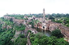
| View from the fort on the city of Chittorgarh | ||
Chittorgarh ( Hindi : चित्तौड़गढ़ Cittauṛgaṛh ; also Chittaurgarh, short Chittor or Chittaur ) is a city in the Indian state of Rajasthan with around 120,000 inhabitants. It is the administrative seat of the Chittorgarh district .
Location and climate
Chittorgarh is located in the southeast of Rajasthan in the Mewar region , of which it was the former capital, near the border with the neighboring state of Madhya Pradesh at an altitude of approx. 400 m . The next largest cities are Bhilwara (54 km north), Udaipur (115 km southwest) and Kota (168 km east). Jaipur , the capital of Rajasthan, is about 300 km to the northeast. Today's city extends at the foot of a 180 m high table mountain on which the fortress Chittorgarh lies, which is considered to be the largest fort in India in terms of area. Chittorgarh has a train station, but is also easily accessible by buses. Motor rikshas drive up to the fort. The climate is warm and rather dry; Rain (approx. 740 mm / year) falls almost exclusively during the summer monsoon season .
population
| year | 1991 | 2001 | 2011 |
| Residents | 71,569 | 96.219 | 116,406 |
About 81% of the population are Hindus , 14% are Muslims , 4% Jains and about 1% belong to other religious groups ( Sikhs , Christians , Buddhists etc.). As is customary in northern India, the male population is around 10% higher than the female population. They speak predominantly Rajasthani (Mewari dialect) and Hindi .
economy
The urban economic structure is mainly based on handicrafts, retail trade and services (transport, banks, etc.). Despite the large number of day-trippers, tourism plays a rather subordinate role, as there were no good hotels until the end of the 20th century.
history
Excavations suggest that the place was already settled in the 1st millennium BC. u. Close Z. The first written mention of the fortress (garh) of Chittor comes from the year 728. Chittorgarh was - until the founding of Udaipur - for a long time the capital of the Rajput state Mewar , which was incorporated into the Indian union state in 1956.
The city is known throughout India and famous because of its centuries-old - handed down in countless legends and stories - tenacious but ultimately unsuccessful resistance against the Muslim conquerors: Allegedly , Sultan Ala ud-Din Khalji, who lived in Delhi, besieged the fortress as early as 1303 because he wanted the beautiful Princess Padmini to be his wife. Shortly before the conquest of the city was looming, the inhabitants committed suicide ( jauhar ) - thousands of women and children died on gigantic pyre, the men opened the gates and plunged into the hopeless fight. Under Rana Kumbha (r. 1433–1468), a new conquest of the city by the army of Mahmud Khilji , the Sultan of Malwa , could be averted in the 1440s ; after that the city experienced a heyday. In 1535, however, the city and fortress were conquered by the troops of Bahadur Shah , the Sultan of Gujarat , and again the women committed suicide and the men died in the hopeless battle.
In the autumn of 1567, the Mughal ruler Akbar I, who was only 25 years old but had ruled for 11 years, besieged the strong fortress, which, however, could only be taken in February 1568 after the walls were blown up. Before that, the women’s Jauhar ritual took place again and the men died fighting. Even before the siege began, the only 13-year-old Udai Singh II , who later became Prince of Mewar, had left the city and sought refuge in Bundi , his mother's hometown, and in the fortress of Kumbhalgarh . Later he was to found the city named after him, Udaipur, as the new capital of Mewar.
The clashes with the Muslim conquerors - now it was the Mughal empire - continued: In 1614, the Mughal army under the leadership of Jahangir devastated vast areas of Mewar, which forced the Rana of Udaipur to a peace treaty which, among other things, stipulated that Chittorgarh should never be rebuilt.
Attractions

All the sights of Chittorgarh are located on or on the 2.8 km² large fortress mountain, which is surrounded by an 11 km long wall. The mountain was fortified as early as under the Maurya rulers (ie in the 3rd or 2nd century BC), and again under the Rajputs who resided here.
- Gates
- The way to the fortress is provided with nine imposing gates, which date from Hindu times, but were later also provided with Islamic building and decor elements.
- Kalika Mata Temple (approx. 700)
- Kumbha Shyama Temple (early 8th century)
- The temple was probably started only a little later than the Kalika Mata temple and has a very similar floor plan consisting of a sanctuary area with a walkway ( pradakshinapatha ) and a pillar vestibule (mandapa) . The pillar reliefs are more mature and deeply worked. The portico with a beautiful Torana arch and the superstructures ( Shikhara tower and vestibule roof) date from the 15th century.
- Sati Ground Temple and Ksemankari Temple (9th century)
- Both temples are partially ruined and - judging by their shape and decor - date from the Pratihara period. They consist only of a cella with rich exterior wall decoration - the open, pillared architecture of the two older temples has not prevailed here.
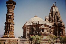
- Victory tower of the Jainas Kirti Stambha (13th century)
- The six- story tower, which looks like an oversized pillar, is 22 m high and was built in honor of the first Jain Tirthankara Adinath and is adorned with a large number of figures from the Digambara sect ("air-clad").
- Mahavira Temple (14th century)
- Right next to the Kirti Stambha of the historical founder of the stands Jainism dedicated to Mahavira Temple in the 14th century.
- Rana Kumbha Palace (15th century)
- The already badly dilapidated palace probably dates from the time of Rana Kumbha, but covers older structures. It could have served as a model for the City Palace in Udaipur.
- Mira Bai Temple (15th century)
- The temple was built by Rana Kumbha; later it was renamed in honor of the princess and poet Mira Bai .
- Victory Tower Rana Kumbhas Vijaya Stambha (15th century)
- The nine-storey, also pillar-like tower reaches a height of approx. 37 m. The outer and inner walls are decorated with figure reliefs from Hindu mythology, but old graffiti with praises to Allah can also be found.
- Padmini Palace (16th - 19th centuries)
- The palace stands on the edge of one of the many water basins ('tanks') in the area of the castle hill and is visibly deteriorating. Allegedly at this point Ala ud-Din Khalji is said to have seen Padmini's reflection in the water.
literature
- Beate Szerelmy, Andrea Wurth and others: India . Baedeker-Verlag, Ostfildern 1997, p. 232f ISBN 3-89525-139-9
- Bamber Gascoigne: The Mughals - splendor and greatness of Mohammedan princes in India . Prisma-Verlag, Gütersloh 1987 ISBN 3-570-09930-X
- Michael W. Meister, MA Dhaky (Ed.): Encyclopaedia of Indian Temple Architecture. North India - Period of Early Maturity. Princeton University Press, Princeton 1991, pp. 285ff ISBN 0-691-04094-X


