Citronelle
| Citronelle | |
|---|---|
 NQ and Virginia M. Thompson House (2010) |
|
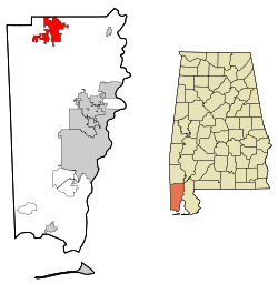
| Location in County and Alabama | |
| Basic data | |
| Foundation : | 1811 |
| State : | United States |
| State : | Alabama |
| County : | Mobile County |
| Coordinates : | 31 ° 6 ′ N , 88 ° 15 ′ W |
| Time zone : | Central ( UTC − 6 / −5 ) |
| Residents : | 3,905 (as of 2010) |
| Population density : | 61.8 inhabitants per km 2 |
| Area : | 63.9 km 2 (approx. 25 mi 2 ) of which 63.2 km 2 (approx. 24 mi 2 ) is land |
| Height : | 95 m |
| Postal code : | 36522 |
| Area code : | +1 251 |
| FIPS : | 01-15064 |
| GNIS ID : | 0116155 |
| Website : | www.cityofcitronelle.com |
Citronelle is a city in Mobile County in the state of Alabama in the United States . In 2010, around 3900 people lived here.
geography
Citronelle is located in southwest Alabama in the southern United States. It is located about 10 kilometers east of the Mississippi border and 18 kilometers west of the Mobile River , which flows a few kilometers south into Mobile Bay and Gulf of Mexico .
Nearby locations include Gulfcrest (5 km south), Deer Park (8 km north), Turnerville (11 km south), Mount Vernon (15 km east), Calvert (15 km east). The next larger city, with 195,000 inhabitants, is Mobile, about 29 kilometers south-east .
history
The area of today's Citronelle was first explored by the French in the 18th century; previously Choctaw and Muskogee Indians lived and hunted here . The area was settled in 1811. The name comes from the French and denotes the citronella from the Cardiopteridaceae family , which grew frequently in this area. In 1852 a post office was established. Due to its climate and location, the city became a popular holiday destination in the late 19th century, which is why numerous hotels were built here.
In 1955, oil deposits were discovered in and around Citronelle and made the city the "oil capital of Alabama" to this day.
Five structures and sites in Citronelle are listed on the National Register of Historic Places as of December 13, 2019, including the Central Core Historic District and the NQ and Virginia M. Thompson House .
traffic
US Highway 45 runs from north to south of the city and connects to US Highway 90 , Interstate 10 and Interstate 65 in the south .
The Mobile Regional Airport is located about 37 kilometers south .
Demographics
The 2000 census showed a population of 3659, divided between 1318 households and 1009 families. The population density was 58 people per square kilometer. 77% of the population were white, 18.7% black, 2.8% Indians and 0.1% Asians. 0.3% were of a different ethnicity , 1.3% had two or more ethnicities, and 0.8% were Hispanics or Latin Americans of any ethnicity. For every 100 women there were 91 men. The median age was 35 years and the per capita income was 16,455 US dollars, which put about 15.4% of the population below the poverty line.
By the 2010 census , the population rose to 3,905.
Web links
- Official website of the city (Engl.)
- Statistical data on Citronelle (Engl.)
Individual evidence
- ↑ Place Names in Alabama , University of Alabama Press, Tuscaloosa 1989, p. 34 ( on Google Books )
-
↑ Search mask database in the National Register Information System. National Park Service , accessed December 13, 2019.
Weekly List on the National Register Information System. National Park Service , accessed December 13, 2019. - ↑ a b site of the United States Census Bureau , accessed on July 7, 2015
