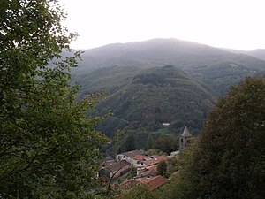
Cutigliano
| Cutigliano | |||
|---|---|---|---|

|
|||
| Country | Italy | ||
| region | Tuscany | ||
| province | Pistoia (PT) | ||
| local community | Abetone Cutigliano | ||
| Coordinates | 44 ° 6 ' N , 10 ° 45' E | ||
| height | 678 m slm | ||
| Residents | 399 (2011) | ||
| patron | San Bartolomeo (August 24th) | ||
| Telephone code | 0573 | CAP | 51024 |
Cutigliano is a place and a former municipality in the Italian province of Pistoia , in the Tuscany region . Cutigliano belongs as a district ( fraction , Italian frazione ) to the municipality of Abetone Cutigliano .
geography
Cutigliano is located at 678 m slm approx. 23 km northwest of the provincial capital Pistoia and approx. 55 km northwest of the regional capital Florence in the climatic classification of Italian communities in zone E, 2 901 GG.
The place lies in the mountain range of the Appennino Tosco-Emiliano on the south side of the mountain Libro Aperto (1937 m) and borders here on the region Emilia-Romagna ( province Modena ). Other mountains in the border region are the Monte Cervinara (1776 m), the Monte Lancino (1702 m) and the Monte Lancio (1549 m), which each represent the northern municipal boundary to the province of Modena.
The most important bodies of water in the former municipality are the Torrenti Lima (7 of 42 km in the municipality) and Sestaione (5 of 11 km in the municipality). The Sestaione flows into the Lima on the right side in the municipality after the district of Ponte Sestaione , the Lima itself is the main tributary of the Serchio , which it meets at Bagni di Lucca . Cutigliano is located in the valley of the Sestaione (Valle del Sestaione) and in the upper part of the Val di Lima (also Valle di Lima )
Melo (1007 m, approx. 55 inhabitants), Pian degli Ontani (856 m, approx. 300 inhabitants), Pian dei Sisi (877 m, approx. 35 inhabitants), Pian di Novello (1134 m ) belonged to the fractions of the former municipality of Cutigliano m, approx. 155 inhabitants), Pianosinatico (948 m, approx. 75 inhabitants), Ponte Sestaione (637 m, approx. 135 inhabitants) and Rivoreta (900 m, approx. 35 inhabitants).
The neighboring communities were Abetone , Bagni di Lucca ( LU ), Fanano ( MO ), Fiumalbo (MO), Piteglio and San Marcello Pistoiese .
history
In 997 Cutigliano was a small village and belonged to the municipality of Lizzano .
The municipalities of Cutigliano and Abetone were merged on January 1st, 2017 to form the new municipality of Abetone Cutigliano .
Attractions
- Chiesa di San Bartolomeo , main church (Parrocchiale) in the town center. Contains the work Madonna del Rosario by Matteo Rosselli , the work Circoncisione (1620) by Giovanni da San Giovanni and the work Nascita della Vergine by Nicodemo Ferrucci . Other works of art are the Madonna del Carmine by Onorio Mariani, San Michele by Alessio Gemignani, Madonna col Bambino, San Giovannino e quattro santi by Giovan Battista Volponi and a Miracolo di San Bartolomeo by Sebastiano Vini from 1570.
- Palazzo Pretorio (Palazzo dei Capitani di Montagna), 14th century palace with 95 coats of arms. It was renovated in the 16th century and equipped with works from the Della Robbia workshop .
- Church of the Madonna di Piazza ( Chiesa della Madonna di Piazza ), was built in the 15th century and contains a work by Benedetto Buglioni from 1510 ( Madonna col Bambino ei Santi Antonio Abate e Bernardino da Siena )
- Museo della Gente dell'Appennino Pistoiese , folklore museum in the Rivoreta district.
traffic
The place is on Strada Statale 12 dell'Abetone e del Brennero .
Demographics
The former municipality of Cutigliano had 1,488 inhabitants (as of December 31, 2015) on an area of 44 km².

Community partnerships
The place has maintained a community partnership with Asnières-sur-Oise ( Département Val-d'Oise , France) since 1990 .
Awards
Cutigliano is the holder of the Bandiera Arancione .
literature
- Emanuele Repetti: CUTIGLIANO (Cutilianum) in Val di Lima. In Dizionario Geografico Fisico Storico della Toscana (1833–1846). Online edition of the University of Siena (PDF, Italian)
- Touring Club Italiano : Toscana. Milan 2003, ISBN 88-365-2767-1 , p. 280 f.
Web links
- Official website of the Pro Loco in Cutigliano
- Pro Loco website at cutiglianovalsestaione.it
Individual evidence
- ↑ La Frazione di Cutigliano with the population figures from 2011, accessed on June 26, 2019 (Italian)
- ↑ Website of the Agenzia nazionale per le nuove tecnologie, l'energia e lo sviluppo economico sostenibile (ENEA), accessed on October 19, 2013 (Italian) (PDF; 330 kB)
- ↑ a b c d Touring Club Italiano: Toscana.
- ↑ Official website of the Sistema Informativo Ambientale della Regione Toscana (SIRA) on the rivers in Cutigliano , accessed on October 19, 2013 (Italian)
- ↑ Emanuele Repetti: CUTIGLIANO (Cutilianum) in Val di Lima.
- ^ Website Turismo in Toscana der Regione Toscana , accessed on October 19, 2013 (Italian)
- ↑ Comune di Abetone Cutigliano with the population figures from 2011, accessed on June 26, 2019 (Italian)
- ↑ a b Regione Toscana: I luoghi della Fede (Montagna Pistoiese), online version , accessed on October 19, 2013 (Italian)
- ↑ www.visittuscany.com: Il Museo della Gente dell'Appennino Pistoiese , accessed on June 26, 2019 (Italian)
- ↑ Official website of the municipality of Abetone Cutigliano on the partnership between Cutiglianos and Asnières-sur-Oise , accessed on June 27, 2019 (Italian)
- ↑ Official website of the Bandiera Arancione zu Cutigliano , accessed on January 6, 2018 (Italian)


