
Döllnitz (Schkopau)
|
Dollnitz
municipality Schkopau
|
|
|---|---|
 |
|
| Height : | 83 m |
| Area : | 61 ha |
| Residents : | 1425 |
| Population density : | 2,336 inhabitants / km² |
| Incorporation : | August 1, 2004 |
| Postal code : | 06258 |
| Area code : | 0345 |
  Location of Döllnitz in Schkopau
|
|
 Döllnitz village church
|
|
Döllnitz is a district of the municipality of Schkopau in the Saalekreis (Saxony-Anhalt) and has approx. 1300 inhabitants.
Geography and local transport
The place is located northeast of the capital of Schkopau and southeast of Halle (Saale) on the highway 170. The White Elster flows south at the place over, across the river lies the conservation area Elster Luppe-Aue .
In local public transport, Döllnitz can be reached via the An der Gartenanlage , Berliner Str. And Mühlenstr. accessible with the following lines:
- 358 ( OBS ): Döllnitz - Zwintschöna - Halle (Saale)
- 724 ( PNVG ): Merseburg - Halle (Saale) - Döllnitz - Röglitz - Schkeuditz
history
The place was first mentioned in 1091 as Tholenici . Döllnitz was until 1815 between the bishopric of Merseburg, which had been under Saxon sovereignty since 1561 ( Electorate of Saxony (from 1561), Saxony-Merseburg (1656/57 to 1738), then Kingdom of Saxony (from 1806)) and the Archbishopric of Magdeburg or the Prussian Duchy of Magdeburg (from 1680) divided. The Saxon-Merseburg part belonged to the Hochstift-Merseburg office of Merseburg until 1815 . The Prussian-Magdeburg part belonged to the Saalkreis and was under aristocratic jurisdiction. During the French occupation (1807-1813) the Prussian part of Döllnitz belonged to the department of the Saale in the Kingdom of Westphalia . He was assigned to the canton of Glaucha in the Halle district .
As a result of the resolutions of the Congress of Vienna , the Saxon part of Döllnitz came to Prussia in 1815. During the political reorganization after the Congress of Vienna in 1815, both districts were attached to the administrative district of Merseburg in the Prussian province of Saxony and assigned to the Saalkreis.
During the district reform in the GDR in 1952, the place became part of the newly cut hall circle in the Halle district . In 1994 Döllnitz joined the Kabelske-Tal administrative association in the Saalkreis. When Döllnitz merged with eight other communities to form the single community of Schkopau on August 1, 2004, the place changed to the Merseburg-Querfurt district . The previous responsibility of the Kabelske-Tal administrative community in the Saalkreis was thus canceled. Döllnitz belongs to the Saalekreis after the renewed regional reform in 2007 .
During the floods in Central Europe in 2013 , large parts of the town were flooded. This was the largest flood for the place in over 400 years.
Culture and sights
- baroque village church
- Storage
- Memorial stone on the corner of Regensburg and Kreutzmannstrasse for the anti-fascist Otto Kreutzmann, who was murdered by the Gestapo in 1937
- Freedom Monument, with pigeon
gallery

Storage facility in Döllnitz
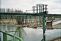
Elsterwehr south of Döllnitz


Web links
Individual evidence
- ^ Karlheinz Blaschke , Uwe Ulrich Jäschke : Kursächsischer Ämteratlas. Leipzig 2009, ISBN 978-3-937386-14-0 ; P. 84 f.
- ↑ Mention of the place in the book "Geography for all Stands", p. 130
- ^ Description of the Saale Department
- ^ The hall circle in the municipality register 1900