Antabamba district
| Antabamba district | |
|---|---|
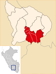
 The Antabamba District is located in the central south of the Antabamba Province (marked in red) |
|
| Basic data | |
| Country | Peru |
| region | Apurímac |
| province | Antabamba |
| Seat | Antabamba |
| surface | 603 km² |
| Residents | 2925 (2017) |
| density | 4.9 inhabitants per km² |
| founding | June 21, 1825 |
| ISO 3166-2 | PE-APU |
| politics | |
| Alcaldesa Provincial | Rocío Narváez Choquecahuana (2019-2022) |
| Political party | El Frente Amplio por Justicia, Vida y Libertad |
Coordinates: 14 ° 22 ′ S , 72 ° 53 ′ W
The Antabamba District is located in the Antabamba Province in the Apurímac region in south-central Peru . The district was established on June 21, 1825. It has an area of 603 km². The 2017 census counted 2925 residents. In 1993 the population was 3729, in 2007 it was 3166. The district administration is located in the provincial capital Antabamba at an altitude of 3636 m with 2160 inhabitants (as of 2017).
Geographical location
The Antabamba district is located in the Andean highlands in the central south of the Antabamba province. The Río Pachachaca (also Río Ichuni and Río Antabamba) flows along the northern district boundary to the west. In the south the district extends to the Cordillera Huanzo mountain range , which reaches heights of over 5200 m . The Río Jeuñamarca crosses the central part of the district in a north-northwest direction.
The Antabamba district borders in the south with the district Huaynacotas ( province La Unión ), in the west with the district Juan Espinoza Medrano , in the north with the district Huaquirca and in the east with the district Oropesa .
Web links
- Peru: Region Apurímac (provinces and districts) at www.citypopulation.de
- INEI Perú