Bolognesi District
| Bolognesi District | |
|---|---|
 Location of the Bolognesi district in the northwest of the Pallasca province |
|
| Basic data | |
| Country | Peru |
| region | Ancash |
| province | Pallasca |
| Seat | Bolognesi |
| surface | 81.8 km² |
| Residents | 1071 (2017) |
| density | 13 inhabitants per km² |
| founding | July 15, 1936 |
| ISO 3166-2 | PE-ANC |
| politics | |
| Alcalde District | Andrés Germán Aparicio Reyes (2019-2022) |
| Political party | Siempre Unidos |
Coordinates: 8 ° 21 ′ 2 ″ S , 78 ° 3 ′ 2 ″ W
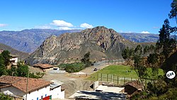
The Bolognesi district is in the Pallasca province in the Ancash region of western Peru . The district was established on July 15, 1936. It has an area of 81.8 km². The 2017 census counted 1071 inhabitants. In 1993 the population was 1508, in 2007 it was 1367. The district administration is located in the 2800 m high village of Bolognesi with 374 inhabitants (as of 2017). Bolognesi is 6.5 km northwest of the provincial capital Cabana .
Geographical location
The Bolognesi district is located in the northwest of the Pallasca province. The Río Tablachaca flows along the northwestern district boundary to the southwest. Its tributaries Río Sacaycacha and Río Boca Cabanas border the district to the north and south.
The Bolognesi district borders in the northwest with the districts Santiago de Chuco and Santa Cruz de Chuca (both in the province Santiago de Chuco ), in the north with the district Pallasca , in the east with the district Huandoval , in the southeast with the district Cabana and in the south to the district of Tauca .
Web links
- Peru: Region Ancash (provinces and districts) at www.citypopulation.de
- INEI Perú
