Calana District
| Calana District | |||
|---|---|---|---|
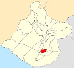
 Location of the district in the Tacna region |
|||
| Symbols | |||
|
|||
| Basic data | |||
| Country | Peru | ||
| region | Tacna | ||
| province | Tacna | ||
| Seat | Calana | ||
| surface | 108.4 km² | ||
| Residents | 2979 (2017) | ||
| density | 27 inhabitants per km² | ||
| founding | August 20, 1872 | ||
| ISO 3166-2 | PE-TAC | ||
| Website | municalana.gob.pe (Spanish) | ||
| politics | |||
| Alcalde District | Juan Ramos Arocutipa (2019-2022) |
||
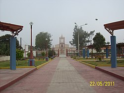
| Plaza de Calana and Seminario San Jose | |||
Coordinates: 17 ° 57 ′ S , 70 ° 11 ′ W
The Calana district is located in the Tacna Province in the Tacna region in the extreme southwest of Peru . The district has an area of 108.38 km². The 2017 census counted 2,979 inhabitants. In 1993 the population was 1,682, in 2007 2,625. The administrative seat of the district is the village of Calana, 10 km northeast of the city of Tacna on the Río Caplina at an altitude of 850 m .
The district lies on the edge of the coastal desert of southern Peru and extends in the east to the foothills of the Peruvian Western Cordillera . It has a longitudinal extension in the WSW-ONE direction of 17 km and a width of about 7 km. The district is bordered to the west by the district Ciudad Nueva , in the north and east by the district Pachía and the south by the district Pocollay .
The district has existed since August 20, 1872.
Individual evidence
- ↑ a b PERU: Tacna region - provinces and districts . www.citypopulation.de. Retrieved January 18, 2020.


