Alto de la Alianza district
| Alto de la Alianza district | ||
|---|---|---|
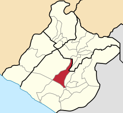
 Location of the district in the Tacna region |
||
| Symbols | ||
|
||
| Basic data | ||
| Country | Peru | |
| region | Tacna | |
| province | Tacna | |
| Seat | La Esperanza (Tacna) | |
| surface | 371.4 km² | |
| Residents | 34,061 (2017) | |
| density | 92 inhabitants per km² | |
| founding | May 9, 1984 | |
| ISO 3166-2 | PE-TAC | |
| Website | www.munialtoalianza.gob.pe (Spanish) | |
| politics | ||
| Alcalde District | Ángel Lanchipa Valdivia (2019-2022) |
|
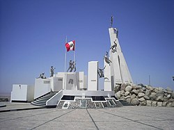
| Monument Pampa Del Cerro Intiorko | ||
Coordinates: 17 ° 54 ′ S , 70 ° 18 ′ W
The Alto de la Alianza district is located in the Tacna Province in the Tacna region in the extreme southwest of Peru . The district has an area of 371.4 km². The 2017 census counted 34,061 residents. In 1993 the population was 26,872, in 2007 35,439. The administrative seat of the district is the city of La Esperanza , a western suburb of the city of Tacna .
The district has a longitudinal extent in NNE direction of about 45 km. Most of it consists of desert. The southern boundary of the district is the national road 1S ( Panamericana Sur) from Tacna to Moquegua . The western boundary of the district forms the course of the Quebrada de Cerrillos Negros. The district is bordered to the west by the district Inclán , the north by the province of Tarata , to the east by the district Ciudad Nueva and the south by the district Tacna .
The district was established on May 9, 1984. On November 20, 1992, the eastern part of the district was detached and has since formed the Ciudad Nueva district. On February 2, 2001 there was another change in the district area.
The district is mainly inhabited by immigrants and their descendants from the Puno region and the mountainous regions of Moquega and Tacna. Even today the settlement areas are separated according to the origin of the population. For example, the population in the Eloy G. Ureta sector has its roots in the Moquegua, Arequipa and Cusco regions, as well as the Sama , Ite and Locumba districts and the Tarata province . The settlements of Pueblo Joven San Martín and Pueblo Joven Alto de la Alianza are mostly inhabited by immigrants from the districts of Tarata , Tarucachi and Candarave . This allows the population to preserve their traditions, customs and festivals.
Web links
- Municipalidad Distrital Alto de la Alianza
- Peru: Region Tacna (provinces and places) at www.citypopulation.de
- INEI Perú

