Ilabaya district
| Ilabaya district | ||
|---|---|---|
 Location of the district in the Jorge Basadre province and in the Tacna region |
||
| Symbols | ||
|
||
| Basic data | ||
| Country | Peru | |
| region | Tacna | |
| province | Jorge Basadre | |
| Seat | Ilabaya | |
| surface | 1,111.4 km² | |
| Residents | 5695 (2017) | |
| density | 5.1 inhabitants per km² | |
| founding | June 25, 1855 | |
| ISO 3166-2 | PE-TAC | |
| Website | www.munilabaya.gob.pe/web/index.php (Spanish) | |
| politics | ||
| Alcalde District | Juan Pedro Paria Gallegos (2019-2022) |
|
| Political party | Alianza por el Progreso | |
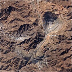
| Toquepala mine | ||
Coordinates: 17 ° 25 ′ S , 70 ° 31 ′ W
The Ilabaya district is located in the Jorge Basadre province in the Tacna region in the extreme southwest of Peru . The district has an area of 1111.39 km² (according to other sources 1058 km²). The 2017 census counted 5695 inhabitants. In 1993 the population was 7817, in 2007 it was 4414. The administrative seat of the district is the village of Ilabaya with 301 inhabitants located on the Río Salado, left source of the Río Locumba , at an altitude of 1425 m (as of 2017). Ilabaya is located about 70 km north-northwest of the regional capital Tacna . In the north-west of the district is the Toquepala mine, in which copper ore is mined in an open-cast mine. The Ilo – Toquepala – Cuajone railway leads there from the neighboring Moquegua region . On the western border of the district there are also the Toquepala Caves with rock carvings.
Geographical location
The Ilabaya district extends over the north of the Jorge Basadre province. It lies on the edge of the desert coastal highlands of southwest Peru and includes the foothills of the Peruvian Western Cordillera in the north . It has a longitudinal extension in WNW-ESE direction of about 43 km and a maximum width of about 30 km. The headwaters of the Río Locumba, Río Cinto and Río Salado, drain the district to the south. The Ilabaya district is bordered to the south by the district Locumba , in the west and northwest on the district Moquegua ( province Mariscal Nieto , Region Moquegua ), in the northeast to the districts Camilaca , Cairani , Huanura and Curibaya (all four in the province of Candarave ) and in South-east to the Inclán district ( Tacna province ).
Localities
Below is a list of towns and settlements in the Ilabaya district.
Centros Poblados:
- Borogueña (280 inhabitants)
- Cambaya
- Mirave (835 inhabitants)
Anexos:
- Chejaya
- Chulibaya
- Oconchay
- Ticapampa Poquera
- Toquepala (3560 inhabitants)
Comunidades campesinas:
- Borogueña
- Carumbraya
- Coraguaya
- Chululuni
- Higuerani
- Santa Cruz
- Toco Chico
- Toco Grande
- Vilalaca
Caseríos:
- Cacapunco
- Chintari
- El Cayro
- El Cocal
- La Haciendita
- Margarata
- Pachana Chapicuca
- Solabaya
Individual evidence
- ↑ a b PERU: Tacna region - provinces and districts . www.citypopulation.de. Retrieved March 22, 2020.


