Moquegua District
| Moquegua District | |||
|---|---|---|---|
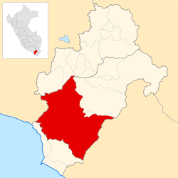
 Location of the district in the Mariscal Nieto province or in the Moquegua region |
|||
| Symbols | |||
|
|||
| Basic data | |||
| Country | Peru | ||
| region | Moquegua | ||
| province | Mariscal Nieto | ||
| Seat | Moquegua | ||
| surface | 3949 km² | ||
| Residents | 65,808 (2017) | ||
| density | 17 inhabitants per km² | ||
| ISO 3166-2 | PE MOQ | ||
| Website | www.munimoquegua.gob.pe (Spanish) | ||
| politics | |||
| Alcalde Provincial | Abraham Alejandro Cárdenas Romero (2019-2022) |
||
| Political party | Unión por el Perú | ||
| Santo Domingo Church in Moquegua | |||
Coordinates: 17 ° 12 ′ S , 70 ° 56 ′ W
The Moquegua district is located in the province of Mariscal Nieto of Moquegua region in southwestern Peru . The district has an area of 3949.04 km². At the 2017 census, 65,808 people lived in the district. In 1993 the population was 35,677, in 2007 it was 49,419. The seat of the district, provincial and regional administration is the 1410 m high city of Moquegua with 37,518 inhabitants (as of 2017). On the southwestern outskirts of Moquegua there is also the suburb of San Antonio with 24,414 inhabitants.
Geographical location
The district extends over the coastal highlands in the south of the Mariscal Nieto province. The Río Tambo flows west along the northwestern district boundary. The Río Moquegua flows through the district in a south-westerly direction. Irrigated agriculture is practiced along the course of the river. The population is concentrated in the Moquegua metropolitan area. Otherwise there is desert vegetation.
The Moquegua district is bordered to the southwest by the districts of El Algarrobal and Pacocha (both in the province of Ilo ), to the west by the districts of Punta de Bombón and Cocachacra (both in the province of Islay ), to the northwest by the districts of La Capilla and Puquina (both in the province of General Sánchez Cerro ), in the north to the districts of Torata and Samegua and in the east to the districts of Ilabaya and Locumba (both in the province of Jorge Basadre ).
Web links
- Municipalidad Provincial Mariscal Nieto
- Peru: Moquegua region (provinces and districts) at www.citypopulation.de
- INEI Perú


